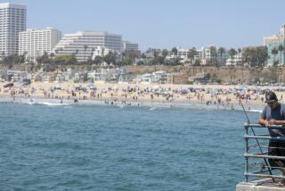
What Winter? Warm Weather to Stick Around for Weekend
Unseasonably warm weather with temperatures 10 degrees above normal at Lindbergh Field invited walkers, joggers and surfers to city and county beaches Thursday. And it was forecast to continue through Saturday in the “afterglow” of this week’s Santa Ana.
According to National Weather Service forecaster Wilbur Shigehara, the Santa Ana that generated strong winds and warm temperatures this week had broken down by Thursday, but a high-pressure system extended the warm, dry and sunny weather.
Temperatures that began rising Tuesday reached a high of 75 Thursday at Lindbergh Field--10 degrees above the norm of 65 degrees. Highs rose to 80 degrees in Fallbrook, Lemon Grove and Vista; to 79 at Escondido, San Diego State University and the Wild Animal Park; to 84 in Imperial Beach; to 81 in Poway; 70 degrees in Oceanside, and to 66 at Mt. Palomar.
City and county lifeguards said beachgoers were taking advantage of an extremely low tide--minus 1.8 feet--for strolling and running along the shore. County lifeguard Andy O’Leary said surfers were crowding Swami’s Beach in Encinitas and about 3,000 people visited county beaches along the North County coast.
The water temperature hovered between 57 and 58 degrees and the surf was average, at three to four feet.
City lifeguard Matt Rowland said Mission Beach was “quite busy,” but most visitors were wading, not swimming, and lifeguards made no rescues Thursday.
Air quality was favorable in all parts of the county, and is expected to be good again today. Pollution Standards Index readings Thursday were 42 at El Cajon; 25 in downtown San Diego, Oceanside, Del Mar and Escondido, and 34 in Kearny Mesa, according to the San Diego County Air Pollution Control District.
Although a thin layer of smog failed to dissipate in some areas, visibility from the Solana Beach lifeguard station at 1 p.m. was a clear 12 miles, O’Leary said.
The weather should continue warm today and Saturday, but humidity may rise over the weekend as winds shift to the familiar southwesterly flow.
Humidity, which had plunged to between 10% and 20% since the Santa Ana winds blew in Tuesday, was a low 11% at 1 p.m. Thursday at Lindbergh Field. The norm is 57%.
On Saturday, “a haze might develop as the air mass that was blown out to sea starts coming back in,” Shigehara said. “I don’t expect a surge of moist air, but the crisp clear visibility might not be so crisp.”
Some fog may roll in along the coast Sunday morning and temperatures throughout the county may be closer to normal as the high-pressure system begins to break down, he said.
Winds had returned to normal velocity by Thursday throughout most of the county, and only gusts through mountains passes were forecast for today. Sailors can expect light west to southwest breezes of 7 to 15 m.p.h.
Daytime temperatures at the beach today and Saturday are expected to hit 68. Coastal strip highs of 75 are expected to fall to the 40s at night.
Inland valley temperatures reaching 80 during the day may plunge into the 30s at night. “It’s not surprising to see temperatures drop 40 to 45 degrees inland at night when the air mass is dry,” Shigehara said.
Mountain highs in the 55- to 65-degree range are expected to fall into the 27- to 37-degree range at night, and desert highs in the 70s may fall to the 30s. Northeast wind gusts may reach 25 m.p.h. in localized mountain areas.
By Monday, the sunny weather may disappear as storms from the west approach San Diego. Long-range forecasts predict cloudier weather with a chance of rain by Tuesday.
More to Read
Sign up for Essential California
The most important California stories and recommendations in your inbox every morning.
You may occasionally receive promotional content from the Los Angeles Times.


