Monster storm forecast worsens for L.A., O.C.: The danger zones, the forecast, the warnings

- Share via
California girded Sunday for a “potentially historic” storm that put much of the state on high alert, with officials expecting life-threatening damage and issuing evacuation orders or warnings in parts of Los Angeles, Orange, Ventura, Santa Barbara and Monterey counties.
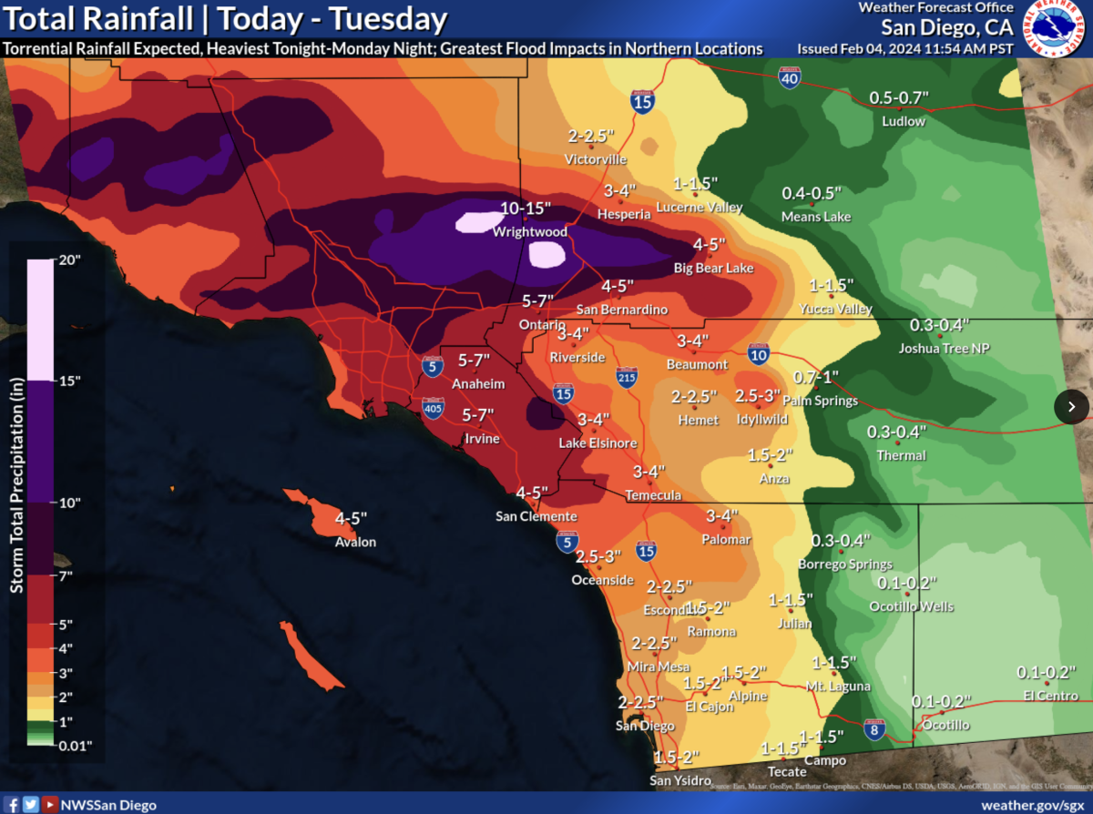
Rain totals that were forecast for Los Angeles County worsened Sunday, with totals generally rising by about 2 inches in some areas. It’s now possible that Pasadena could see up to around 10 inches of rain; Northridge, Pomona and Santa Clarita could be hit by about 7 inches; downtown Los Angeles, Long Beach and Westlake Village about 6 inches; and Redondo Beach about 5 inches.
The forecast also worsened for Orange County, the Inland Empire and the San Bernardino Mountains, especially for Monday. The National Weather Service now warns of “locally catastrophic and life-threatening flooding” for those areas, with officials stating “the system will stall, bringing heavy rain through Monday afternoon.” Between 5 to 7 inches of rain could drench Anaheim, Irvine and Ontario.
Forecasters said the Los Angeles area, where the system could park for a long time Sunday into Monday, was of major concern.
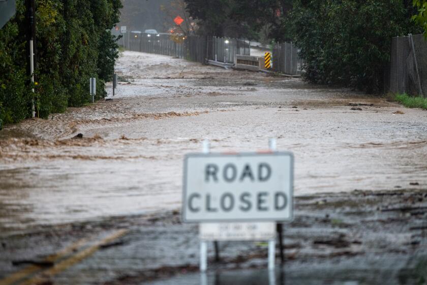
“That’s a lot of water, people. I mean, that’s a lot,” meteorologist Ryan Kittell of the National Weather Service office for Los Angeles said at a briefing Sunday. “We’re expecting a lot of freeway flooding and road flooding, road closures. Many parked cars will be flooded ... especially in low-lying areas of neighborhoods.”
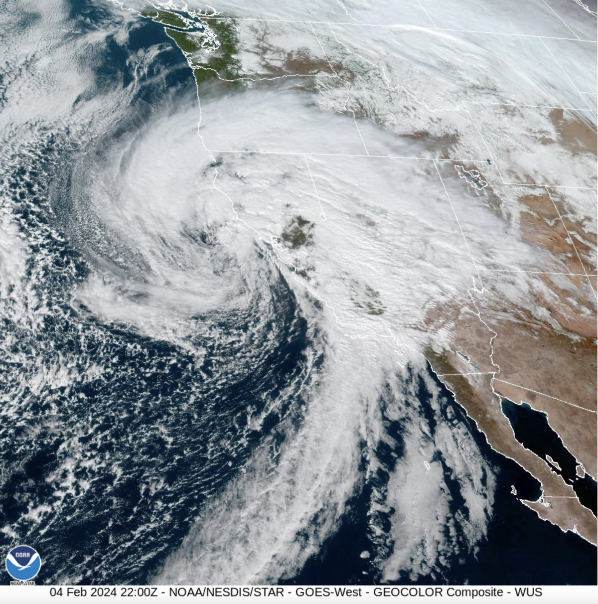
The weather system was threatening flooding because it is “very slow moving,” Kittell said. “The core of the low pressure system is very deep, and it’s moving very slowly and it’s very close to us. And that’s why we have those very strong winds. And the slow nature of it is really giving us the highest rainfall totals and the flooding risk.”
Chilling rain, swirling gray clouds and blustery winds rolled into Southern California on Sunday as what was anticipated as the strongest storm of the season promised near-record rainfall and flash flooding through Tuesday.
For some of the populous areas of Southern California, this storm will bring winds that will actually be “much stronger” than Tropical Storm Hilary last August, especially in the lower elevations, Kittell said. Hilary brought most of its rain on the inland side of Southern California’s mountains and in the deserts; this weekend’s storm is focused on “the coastal side of the mountain — so where a lot of people live ... the urban, city areas along the coast and valleys, and the south-facing foothills,” Kittell said.
Kittell suggested people avoid being on the roads in Los Angeles and Ventura counties between Sunday afternoon through Monday morning. “Even if the rain does start to let up on Monday morning, just the sheer amount of rain overnight will cause lingering flooding issues into the morning hours,” Kittell said, suggesting people work from home Monday morning if possible. “Especially, stay off the freeways.”
“If you are not home already, please get home and stay home. Stay off the roads,” Los Angeles Mayor Karen Bass said Sunday. “As we anticipate this weather event continuing into the next couple of days, if you are able to work remotely, please stay home.”
L.A. City Council President Paul Krekorian said the anticipated amount of rainfall is rare for Los Angeles, and noted that “we’ve only had this kind of intensity twice before in the last over 40 years, so take it seriously.”
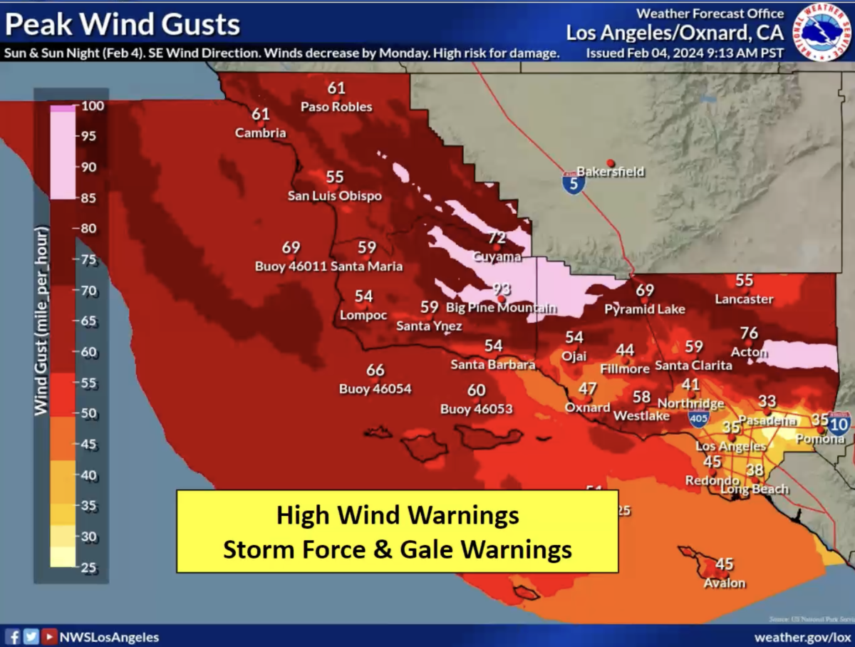
Peak wind gusts could be between 30 mph to 40 mph in downtown L.A., Long Beach, Pasadena and Pomona; between 40 to 50 mph in Northridge and Redondo Beach; and nearly 60 mph in Santa Clarita and Westlake Village.
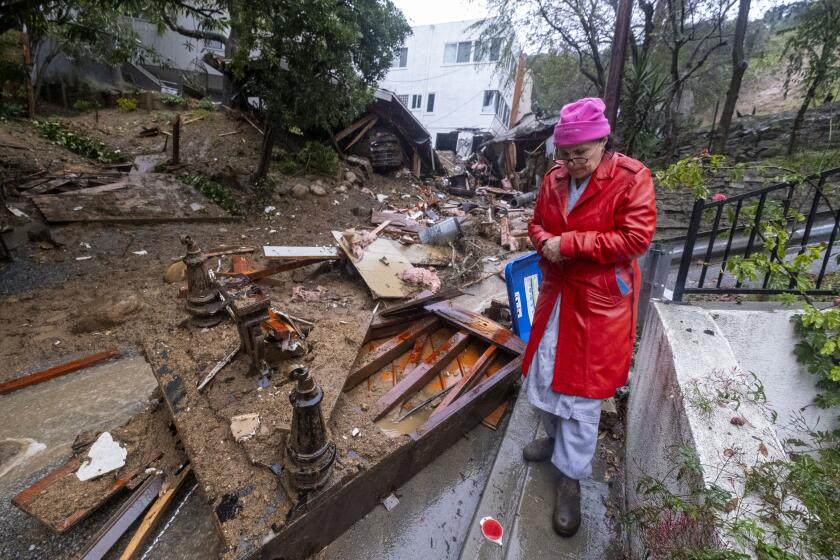
Floodwaters were starting to rise in low-lying spots around Los Angeles County Sunday, stranding motorists in the San Fernando Valley that needed rescue, firefighters said, while 19 people were rescued off the coast of Long Beach after the mast of the ship they were on broke. Elsewhere around the state, rescuers helped evacuate people and dogs from an island in the Guadalupe River in San Jose; and trees plunged into homes across Northern California, and one fell on Highway 101 near Santa Rosa, injuring a motorist.
Thousands of Southern California Edison customers were without power Sunday, and hundreds of thousands were without power in Pacific Gas & Electric’s territory.
On Sunday night, Santa Barbara Airport was forced to be closed “due to flooding on the airfield,” the airport said. “All commercial flights have been canceled, private and general aviation operations are paused, and the terminal is closed until further notice.”
“This storm is predicted to be one of the largest and most significant in our county’s history, and our goal is to get through it without any fatalities or any serious injuries,” Santa Barbara County Sheriff Bill Brown said at a briefing.

This storm could surpass the effects of a powerful storm that hit Jan. 9, 2023, said David Neels, the Montecito fire chief. That event forced the mass evacuation of Montecito, flooded Santa Barbara and left U.S. 101 covered with mud, forcing its closure. It caused more than $80 million in damage to Santa Barbara County, Brown said.
“Our slopes are saturated once again,” Neels said, adding that geologists are warning about the potential for landslides from this storm. “The likelihood of sediment mobilization is real.”
Brown said 6 to 12 inches of rain is expected for Santa Barbara County’s mountains. “But more concerning is the projected duration and sustained amount of rain that we can expect this weekend,” he said.
“Unlike the rain that caused [last year’s Jan. 9] debris flow, for example, the intensity of this storm’s rain is not expected to exceed an inch or an inch and a quarter per hour. It’s just that the rainfall will be far more sustained, over a more or less continuous period for 24 hours or more,” Brown said. “We’re anticipating the possibility of flooding of streets and neighborhoods and of our highways and freeways.”
Kittell said Sunday that more recent forecasts have reduced, in southern Santa Barbara County, the duration of the heaviest rain. Still, flooding there remains a big concern, with rainfall amounts still similar to last year’s Jan. 9 debris flow. That’s “a big deal, still,” Kittell said.
Los Angeles issued an evacuation order for about 50 homes and businesses along a section of La Tuna Canyon Road in Sun Valley on Sunday morning, around where McDonald Creek drains into La Tuna Canyon. The county Department of Public Works warned that heavy rain would bring significant flooding and mudflows to the area, perhaps as much as 28,000 cubic yards if a debris flow occurred. The area is at higher risk of landslides due to the Land fire that burned in 2022, officials said.
Evacuation orders or warnings were also issued for other recently burned areas in Los Angeles County.
Orange County issued an evacuation warning Sunday night for areas in the Santa Ana Mountains, including along sections of the Santiago, Silverado, Williams, Modjeska, Trabuco, Live Oak, Rose, Holy Jim and Black Star canyons Sunday night, as well as around Irvine Lake.
The National Weather Service said there was a “high risk for flash flooding,” a designation used only a few times a year anywhere nationwide, meteorologist Ariel Cohen said at the briefing.
“About half of flood-related deaths occur in high-risk areas. This includes all of the Santa Barbara area, all the way to Los Angeles. This is a particularly dangerous situation,” Cohen said. “I can’t stress enough the importance that everyone be at a very high state of readiness. Take those precautions to save your life from the upcoming floodwaters that will affect the Santa Barbara area.”
The National Weather Service issued an extraordinarily rare “hurricane force wind warning” overnight just off the Central California coast, stretching from the Monterey Peninsula, past Big Sur, to the northern edge of San Luis Obispo County. There hasn’t been a hurricane force wind warning issued off the California coast for at least decades, the weather service said.
A tornado or two are possible in the San Francisco Bay Area, as well as in Santa Cruz, Monterey and San Benito counties. There’s a rare risk of tornadoes also in the Los Angeles area.
The storm was hitting the San Francisco Bay Area and the Central Valley earlier Sunday, and was already causing trees to fall. But the most significant rainfall totals for the state are expected in Southern California and on the Central Coast, National Weather Service meteorologist Eric Schoening said at a separate briefing.
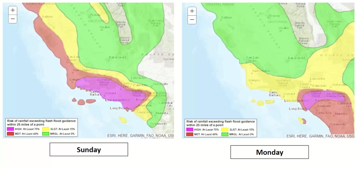
Los Angeles County, as well as Ventura, Santa Barbara and San Luis Obispo counties, were designated as having the highest weather risk level — extreme, colored in purple, the worst on a five-level scale. Forecasters said there was a 40%-to-70% chance of life-threatening and damaging flooding in those areas.
Forecasters said there would also be an extreme weather risk level Monday for Orange County, the Inland Empire, the Santa Ana Mountains, the San Bernardino Mountains and the beaches of Orange County.
Heavy snowfall is expected for the mountains, Schoening said, and gusts are expected to down trees and power lines.
Headlights on. Foot off the gas pedal. And if you see a flooded street, turn around. Here are tips for driving safely as California gets drenched.
“These next storms are going to be impactful and dangerous, and most of the damaging impacts most likely to our coastal and southern regions in the state,” said Nancy Ward, director of the California Governor’s Office of Emergency Services, at the briefing. Storms are “the most dangerous natural disasters that we have — killing more people ... than wildfires every year.”
Ward urged that people avoid nonessential travel during the storm’s peak.
“Don’t walk, swim or drive through flooded waters,” Ward said. “Six inches of water can down an adult in that water. Twelve inches of water can sweep away your vehicle.”
Five rivers in California are anticipated to hit the flood stage: the Ventura River in Ventura County, the San Diego River in San Diego County, the Guadalupe River in Santa Clara County, the Carmel River in Monterey County and the Russian River in Mendocino County, said Karla Nemeth, director of the California Department of Water Resources.
There are also 16 river systems that could hit flood monitor stage. In the Central Valley, reservoirs were already starting to drain stored water downstream to make way for incoming floodwaters, Nemeth said.
Warm ocean waters are upping the odds of significant downpours and offering a preview of the state’s future in a warming world, experts say.
The powerful storm is arriving through an atmospheric river, a long plume of water vapor that pours into California from the Pacific Ocean. It carries so much water that it’s likened to a river in the sky.
Here’s a more detailed look at the forecast by region.
Los Angeles, Ventura, Santa Barbara and San Luis Obispo counties
Risk level: Extreme (worst level on a five-point scale).
Peak timing of storm: Sunday through Monday. Very heavy rain is forecast in L.A. County between Sunday evening into Monday morning; in Ventura County, between midday Sunday through Sunday night; and in Santa Barbara County, on Sunday afternoon.
In a briefing, meteorologist Robbie Munroe called incoming system a “potentially historic storm.”
“It looks like ... the worst rainfall and wind really is in that Sunday-to-maybe-Sunday-night time frame. But following that very heavy rain and very wet conditions, any additional rainfall Monday, Tuesday and even beyond really exacerbate things,” Munroe said.
On Sunday, there’s a “high risk” — at least a 70% chance — of excessive rainfall leading to rapid onset flooding in large portions of Ventura and Santa Barbara counties, and a “moderate risk” — at least 40% chance — of that in a wide swath of northern and western Los Angeles County and coastal San Luis Obispo County.
On Monday, there’s a “moderate” risk of excessive rainfall in eastern and southern L.A. County.
Thunderstorms: There’s a chance Sunday, Monday and even Tuesday.
Peak rainfall rates: It’s possible in some areas, especially south-facing foothills, that 2 to 3 inches of rain could fall within three hours. If that happens, that “could be a huge problem,” Munroe said.
Peak winds: Peak wind gusts could hit 40 mph to 60 mph across the region, with gusts of up to 90 mph in the mountains. Officials said to expect delays at airports. Peak winds for L.A. County are expected Sunday afternoon through Monday morning.
Atmospheric rivers are descending on Southern California. Here’s how to prepare and stay safe before and during the storms, heavy rain and potential flooding.
Snow: Avalanche potential exists at an elevation of 7,000 feet above sea level, and there’s a heavy snow risk at elevations above 6,000 feet. “Residents might need to be prepared to be stranded for several days,” Munroe said. There could be traffic issues along the Grapevine section of Interstate 5.
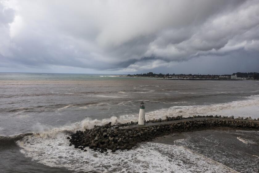
Coast: Expect flooded beach areas and coastal erosion and dangerous surf. Residents who live in flood-prone areas should move their cars out of low-lying areas, Munroe said.
Orange, Riverside, San Bernardino and San Diego counties
Risk level: Extreme risk level is expected for Monday in Orange County, the Inland Empire, the Santa Ana Mountains, the San Bernardino Mountains and the beaches of San Diego County. Major to moderate risks are forecast elsewhere.
Peak timing: Forecasters expect the storm to slow down or stall over Orange County, the Inland Empire and the San Bernardino Mountains for much of Sunday and Monday.
Snow: Heavy snow could cause power outages and make traffic difficult in the mountains. “Heavy wet snow expected on Monday evening into Tuesday,” forecasters said.
Winds: Strong winds could be powerful enough to blow down tree limbs and make driving difficult for high-profile vehicles. In the San Bernardino Mountains into the high desert, there could be gusty winds in excess of 50 mph, and even up to 70 mph, Roser said.
Greater San Francisco Bay Area
Risk level: Extreme in Monterey and San Benito counties on Sunday; major to moderate in the San Francisco Bay Area and Santa Cruz County
Peak timing: Early Sunday into Sunday evening.
Winds: Gusts of above 60 mph are possible; with gusts of more than 75 mph possible in the Santa Lucia Range above Big Sur. Reports of downed trees came in from across the Bay Area Sunday.
San Francisco International Airport was affected by strong winds.
“Loose or unsecured objects may be blown away,” the weather service said in an email. “Strong winds may produce difficult driving for high-profile vehicles.”
Thunderstorms: There is an increased thunderstorm risk in the South Bay and Central Coast areas. Tornadoes are possible.
Impacts: Downed trees and landslides are possible, including along the River fire burn scar in Monterey County. “People living unhoused along the Guadalupe River will be ordered to evacuate,” San Jose officials said.
Central Valley and Sierra Nevada
Risk level: Major to moderate.
Peak timing: Sunday and Monday. Moderate to heavy rain is forecast for the Sierra Nevada, the Sierra foothills and the Kern County desert. The winter storm “could easily be the strongest of the season,” the weather service office in Reno said.
Impacts: Flash flooding and landslides are possible, and travel will be difficult. “Gusts of up to 80 mph are conceivable along the Grapevine” section of Interstate 5, the weather service said. “Avoid large trucks and tractor trailers, slow down, and hold on to the steering wheel with both hands.” Rain and wind will be the main issues at the Grapevine, not snow.
As for the Sierra Nevada, “we still have high confidence in major snow impacts and whiteout conditions,” wrote weather service meteorologist Brian Brong. Forecasters warned of “near impossible mountain travel” Sunday into early Monday.
An avalanche watch was issued by the Eastern Sierra Avalanche Center.
Areas of concern
Ventura County
The sheriff on Saturday issued issued evacuation orders and warnings. Residents of Matilija Canyon and Camino Cielo in unincorporated Ojai were ordered to vacate from 5 p.m. Saturday to at least 5 p.m. Sunday; others were warned that they may have to do so. The sheriff’s office also told residents of La Conchita to prepare for the possibility of landslides or debris flows. The hillsides above the community have received nearly 4 inches of rain over the last two weeks and may see an additional 3 to 5 inches over the next five days, the sheriff’s office said.
A shelter will operate at Ventura College gymnasium at 4667 Telegraph Rd. starting Sunday morning.
Santa Barbara County
Officials are urging residents to stay away from rivers, creeks, flood-prone, low-lying areas and wildfire burn scars, which can turn into dangerous mud and debris flows during heavy rains. Beaches, bluffs and harbor areas may see coastal flooding and erosion, and residents and visitors are advised to stay away.
Evacuation orders were issued for properties along waterways associated with the Thomas, Cave and Alisal burn areas and, in the city of Santa Barbara, those in the vicinity of Sycamore Creek, from Stanwood Drive to parts of Ninos Drive.
Los Angeles County
Officials are keeping a close eye on the Palos Verdes Peninsula, which saw devastating land movement last summer and a mudslide Thursday, as well as Long Beach and areas along the San Gabriel Mountains, according to Emily Montanez, associate director with the L.A. County Office of Emergency Management.
An evacuation order was issued for La Tuna Canyon Drive starting at Martindale Avenue to the east, Penrose Street to the south, Ledge Avenue to the west and Horse Haven Street to the north. Shelters were set up at Sunland Senior Citizen Center at 8640 Fenwick St. and Lake View Terrace Recreation Center at 11075 Foothill Blvd.
Evacuation orders or warnings were also issued along a section of Soledad Canyon Road, east of Santa Clarita, which was affected by the Agua fire; a portion of the Topanga Canyon area, affected by the Owen fire; in the high desert, the Juniper Hills and Valyermo areas, affected by the Bobcat fire; areas in the Lake Hughes and King Canyon areas, affected by the Lake fire; and in Duarte, an area on Melcanyon Road, affected by the Fish fire.
More safety information
- The Times’ complete guide to storm safety preparedness
- How to drive in the rain
- What we know about this storm
- Preparing for disaster if you are disabled
- Understanding mudslides
- Signing up for emergency alerts
More to Read
Sign up for Essential California
The most important California stories and recommendations in your inbox every morning.
You may occasionally receive promotional content from the Los Angeles Times.
