‘Extremely dangerous situation’: Hollywood Hills hit by major mudslides, flooding, record rain

- Share via
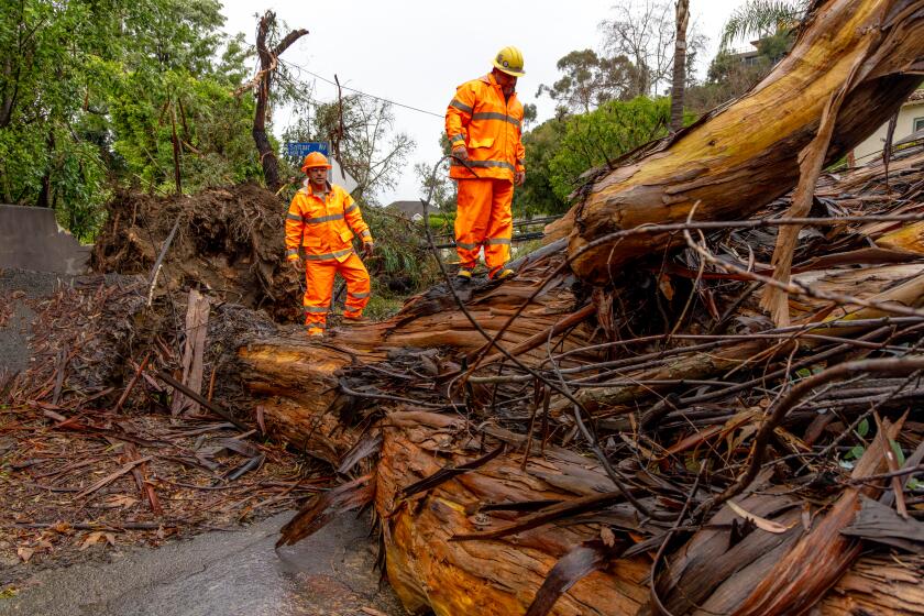
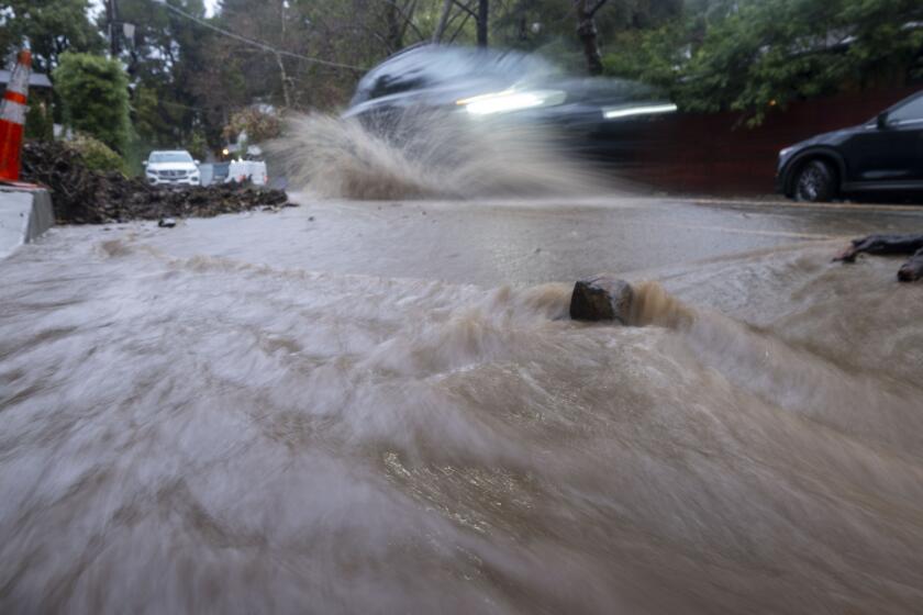
An “extremely dangerous situation” was unfolding in the Hollywood Hills area and around the Santa Monica Mountains Monday, as a powerful, slow-moving storm triggered mud flows and debris flows that damaged some homes and forced residents to evacuate.
Damage reports piled up early Monday as the storm system steadily pummeled Southern California, and downtown L.A. broke a 97-year-old rainfall record.
On Sunday, downtown had seen 4.1 inches of rain, which broke the record for the calendar day set on Feb. 4, 1927, when 2.55 inches of rain was recorded. Sunday was the third wettest February day on record and tied for the 10th wettest day for any time of year since record keeping began in 1877, the National Weather Service said. (The wettest day ever was March 2, 1938, which brought 5.88 inches of rain.)
But the rain is expected to continue though Monday and into Tuesday, heightening the danger across Southern California.
“The main plume of moisture and organized rain has stalled over Los Angeles and Orange counties, going into Riverside County,” Ryan Kittell, a meteorologist with the NWS in Oxnard, said Monday. “All of our projections are showing it being there for the better part of the day, and maybe even spreading to the north — to Ventura and Santa Barbara counties — by the afternoon.”
The greater metropolitan area is expected to see more rain through Monday night, followed by on-and-off rain Tuesday, and possibly even some showers Wednesday, Kittell said.
“There’s still a lot of rain to come,” he said. “There’s a lot of rain left.”
In addition to daily records set Sunday, rainfall totals from the storm were still piling up Monday morning, Kittell said. That includes 10.28 inches in the Topanga area, 9.84 inches around Bel-Air and 5.3 inches in downtown L.A. — with more on the way.
“It’s just a tremendous amount of rain in the last 24 hours,” Kittell said.
Forecasters also expressed deep concern about Griffith Park, nearby foothills and Malibu and Beverly Hills. A flash flood warning was in effect for the area Monday morning.
“Doppler radar indicated heavy rain,” the weather service said. Five to eight inches of rain had already fallen in that area, forecasters said late Sunday night, and an additional 1 to 4 inches were possible in this area Monday morning.
“We are seeing a lot of rescues of cars on roads, due to mud and debris flow, in the Hollywood Hills and up into the Santa Monica Mountains,” National Weather Service meteorologist Todd Hall said Monday morning. “Communities, such as Pacific Palisades, Bel Air, Studio City, Sherman Oaks, Encino, and Topanga are being affected by reports of debris flow going into homes.”
Mud was already flowing across the Hollywood Hills, damaging homes and forcing residents to flee.
In Studio City late Sunday, a debris flow sent mud and other objects flowing down the 11900 block of Lockridge Road, just off of Fryman Canyon, damaging at least two homes, Los Angeles firefighters said. All nine homes on Lockridge Road were evacuated, including pets, “in case further soil instability causes another flow,” firefighters said. There were no injuries. Sixteen residents were displaced.
Here are areas in L.A, Ventura, Orange and San Bernardino counties with evacuation orders or warnings in place. Sand and sand bags are available.
About eight miles to the northwest in Tarzana, firefighters after midnight Monday reported at least three homes affected by a small flow of debris on the 18000 block of Boris Drive. Firefighters evacuated residents from one of the houses.
Elsewhere in the Hollywood Hills, Fox 11 reported Monday morning that mud flows and tree branches were blocking portions of Beverly Glen Boulevard. The station also quoted a resident who said a hillside had come down on the 10000 block of Caribou Lane, slamming into an unoccupied home, pushing it off its foundation and trapping some neighbors in another house.
“The whole hillside came down, shoved the house into our road here and up against our neighbor’s porch and driveway, and it trapped a few people. Actually, our friend Dave is still trapped with his girlfriend up there,” the resident told the station.
“The whole house is down. And there was a piano in the street earlier,” the resident said.
Another resident, who was a part of the local neighborhood council, told Fox 11 he fled with his wife after the landslide, saying there was a natural gas leak in the neighborhood that residents couldn’t shut off because the gas pipe had been sheared off. Another neighbor’s carport was crushed. The TV station said 10 residents from five homes in that neighborhood had to evacuate.
Off Long Beach, 19 people Sunday were rescued from the rocks of the breakwater after the mast of the 40-foot boat they were on broke in high winds.
Eleven people climbed onto the rocks, where they were rescued, and eight more were picked up “by a good Samaritan” before the professional rescuers arrived, said Brian Fisk, firefighter and Long Beach Fire Department public information officer.
Nineteen people were rescued after the mast on their 40-foot boat broke amid high winds and crashed during Sunday’s storm.
Elsewhere in the region, forecasters also warned of a high risk for excessive rainfall for Orange County and parts of the Inland Empire through Tuesday morning.
The Los Angeles County Sheriff’s Department warned that all canyon roads leading to and from Malibu had been hit by rock and mudslides. On Sunday night, Malibu Canyon Road was closed between Malibu Crest Drive and Mulholland Highway.
In Tarzana, swift-water rescue teams responded to motorists stuck in floodwaters at West Oxnard Street and Donna Avenue. Images on social media showed rising waters and cars stalled amid local flooding.
Caltrans reported a small landslide that forced the closure of the road connecting southbound Interstate 5 to the southbound 110 freeway.
Around 7:30 p.m., all lanes of Interstate 5 were flooded in Sun Valley, officials said.
Overnight, flows of mud forced a closure of a section of La Brea Avenue near Stocker Street, KTLA-TV reported.
State Route 33 north of Ojai, up to Lockwood Valley Road, was ordered closed due to landslides, Caltrans said.
Road flooding early Monday morning was also reported around the Interstate 10 and Highway 57 interchange.
The L.A. Department of Water and Power reported 4,674 customers experiencing power outages as of 8 p.m. Sunday. Southern California Edison reported about 8,000 customers without power as of Monday at 12:30 a.m., and Pacific Gas & Electric reported more than 650,000 customers without power as of 7 p.m. Sunday. Power had been restored to an additional 415,000 PG&E customers who had lost power since Sunday morning.
Among the customers who lost power was Action News Now, a Chico television station which broadcasts news for CBS, NBC and CW stations in the northern Sacramento Valley. The station was able to broadcast using generators for their 11 p.m. news Sunday.
In Los Angeles, city workers tallied 254 fallen trees and branches, 549 pothole reports and 106 catch basins cleared to deter flooding.
Los Angeles police recorded 21 ambulance calls for traffic incidents between 6 a.m. and 6 p.m. Sunday, with no fatalities.
Los Angeles Unified announced that, despite the storm, campuses would remain open — pending other developments — except for Vinedale Preparatory Academy, which sits within the La Tuna Canyon Road Evacuation Zone. Students and staff will relocate to Glenwood Elementary.
Areas at risk of flooding or mudslides — a danger in recent hillside burn areas — are under evacuation orders. Within Los Angeles, officials ordered evacuations for La Tuna Canyon Road, roughly within the area bounded by Horse Haven Street to the north, Martindale Avenue to the east, Penrose Street to the south and Ledge Avenue to the west. The area is threatened by the deluge pouring onto the burn scars left by the 2022 Land fire.
Even for those passing through, La Tuna Canyon Road, in the Sunland area, should be avoided. Several sections allow for resident access only. At least one portion is entirely closed.
Forecasters said the Los Angeles area, where the system could park for a long time Sunday into Monday, was of major concern.
In the Sepulveda Basin, Burbank Boulevard is closed between the 405 Freeway and Balboa Boulevard. Woodley Avenue is closed between Burbank and Victory boulevards.
San Bernardino County declared a state of emergency Sunday night in anticipation of damage from the powerful storm. Officials in Yucaipa issued an evacuation warning “due to potential mud and debris flow” for areas burned by the El Dorado and Apple fires.
In the Cajon Pass, three people were stranded in a tree early Monday after their car was flooded out while they tried to cross a submerged area, along Keenbrook Road around Cajon Boulevard.
San Bernardino County firefighters said swift-moving water was hampering rescue efforts, but later reported a successful rescue. The motorists were being evaluated for hypothermia, firefighters said, but were otherwise not injured.
Across the region and state, reports of damage and rescues were multiplying.
Whipped by powerful winds, trees fell on homes across Northern California, and one crushed a car on Highway 101 near Santa Rosa, injuring a motorist. Peak gusts even exceeded 100 mph at Pablo Point in Marin County, which hit 102 mph. Other notable gusts occurred at Loma Prieta, the highest peak in the Santa Cruz Mountains, which hit 98 mph; and Point Reyes in Marin County, which recorded a gust of 89 mph.
In the San Francisco Bay Area, firefighters rescued a person off a sailboat on the rocks just off the Alameda coast, KTVU-TV reported. Firefighters in San Jose rescued stranded people and dogs from an island in the flooding Guadalupe River.
There were reports of street flooding in Seal Beach and Huntington Beach. Caltrans said Pacific Coast Highway along Bolsa Chica State Beach was closed due to flooding.
Local news outlets reported that firefighters in Ventura rescued a person trapped on an island in the Ventura River underneath the 101 Freeway. There were no reports of injuries.
In the eastern Sierra, U.S. 395 was shut overnight Sunday north of Mammoth Lakes, past Mono Lake, all the way to Bridgeport.
Santa Barbara Airport closed due to flooding on the airfield. The airport received 2.39 inches of rain Sunday, breaking the record for the calendar day last set on Feb. 4, 1990, when half an inch fell.
A 70-foot falling tree forced residents to evacuate a two-unit condo in Goleta, displacing four residents and a dog, the Santa Barbara County fire department said early Sunday.
Santa Barbara’s public schools and community colleges will be closed on Monday.
A wide-ranging flood watch was in effect throughout Southern California until 4 p.m. Tuesday amid a forecast of rain, rain and more rain: 4 to 8 inches generally and 8 to 14 inches in the foothills and mountains, according to the National Weather Service. Peak rates will reach an inch an hour and 3 inches in three hours, exacerbating the risk of localized flooding.
Through 1 a.m. Monday, peak wind gusts were expected to be 30 to 50 miles per hours in L.A. and Ventura counties and 50 to 70 miles per hour in mountains and hills. Winds are expected to diminish on Monday.
On Sunday, snow levels dropped to 6,500 feet. They will drop lower as the week progresses — to 5,000 feet on Tuesday. From 5,000 to 6,000 feet in elevation, about 4 to 8 inches of snow will fall; from 6,000 to 7,000 feet the accumulation will be 10 to 20 inches. Above 7,000 feet 2 to 5 feet of snow will fall.
The slow-moving atmospheric river gathered strength Sunday afternoon, spurring Gov. Gavin Newsom to declare a state of emergency in eight Southern California counties: Los Angeles, Orange, Riverside, San Bernardino, San Diego, San Luis Obispo, Santa Barbara and Ventura. The National Weather Service in Oxnard warned that “all systems are go for one of the most dramatic weather days in recent memory.”
Forecasters said the storm appeared to be focused on the Los Angeles area, where it could park itself for the next few days. The storm could drop up to 8 inches of rain on the coast and valleys and up to 14 inches in the foothills and mountains.
At a briefing Sunday afternoon, Los Angeles Unified Supt. Alberto Carvalho announced that schools would remain open Monday, except for Vinedale Span School in Sun Valley, which is affected by city-ordered mandatory evacuations. He called on parents and staff to look for updates Sunday night and Monday at 6 a.m.
Santa Barbara County school districts opted to close Monday. Meanwhile, at least seven Cal State campuses — Long Beach, Dominguez Hills, Fullerton, Los Angeles, Northridge, Pomona, and San Bernardino — alerted students and staff that classes would move online.
The weather service issued dozens of flood watches and storm advisories across the state, including flash flood warnings in parts of San Luis Obispo, Santa Barbara, Ventura and Los Angeles counties.
Kittell, the meteorologist, said the storm could make a mess of the Monday-morning commute in L.A. County.
“If anyone has an opportunity to work remotely on Monday, that’s definitely the day to do it,” he said.
Forecasters were also warning of “torrential” rain in areas of Orange County, the Inland Empire and coastal slopes of the San Bernardino Mountains. The weather service warned Sunday afternoon of “locally catastrophic and life-threatening flooding,” stating that the storm system would “stall, bringing heavy rain through Monday afternoon.” From 5 to 7 inches of rain could drench Anaheim, Irvine and Ontario.
More to Read
Sign up for Essential California
The most important California stories and recommendations in your inbox every morning.
You may occasionally receive promotional content from the Los Angeles Times.
