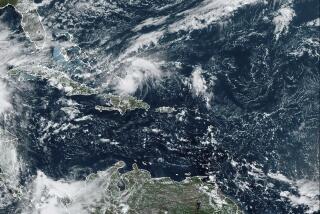
Tropical Storm Floyd Picks Up Steam; Hurricane Flags Are Posted
MIAMI — Tropical Storm Floyd picked up power Sunday in the Western Caribbean as its winds reached 55 m.p.h., and forecasters posted hurricane warnings for southwest Florida and the Florida Keys.
The warning indicates hurricane conditions were expected today across the Keys, Dry Tortugas, Florida Straits, Florida Bay and about one-third of the way up Florida’s Gulf Coast to Venice. Small craft were advised to remain in port north to Tarpon Springs, about 25 miles northeast of Tampa.
Late Sunday, the storm’s center was on the western tip of Cuba, about 275 miles southwest of Key West.
The storm was moving north at 15 m.p.h. and was expected to turn gradually to the northeast today, said forecaster Hal Gerrish at the National Hurricane Center.
“The atmospheric conditions are favorable for a continued slow intensification,” said meteorologist Mark Zimmer. “It’s quite likely it will reach hurricane intensity within the next day or two.”
Small craft around the northwest Caribbean were also warned to remain in port, and residents of the Florida Keys and the southwest part of the state were advised to monitor the storm’s progress.
The sixth storm of the 1987 Atlantic hurricane season, it grew from a tropical depression that had been stalled in the western Caribbean.
“Meteorologically, this is not an unusual situation for October,” Zimmer said, although he added that the last hurricane to come out of the western Caribbean in October was Gladys in 1968.
“Traditionally, toward mid-October the disturbed areas will sit there and stew, then move out,” he said.
Two of this year’s storms attained hurricane status. Hurricane Emily killed three people on its destructive path across the Dominican Republic before slamming into Bermuda, and Hurricane Arlene fizzled in the open Atlantic.
More to Read
Sign up for Essential California
The most important California stories and recommendations in your inbox every morning.
You may occasionally receive promotional content from the Los Angeles Times.


