The Sacred Land of the Ancient Mayas
TIKAL, Guatemala — Dark, leaden clouds hang low over the treetops, dripping lacy tendrils like a gray Spanish moss. Perhaps the threat of rain is a belated answer to the imprecations--and sacrifices, human and otherwise--of ancient Maya priests.
Almost obscured in the mist is the forest of northern Guatemala, the region called the Peten. It’s the part of this Central American nation that’s on the lowland plain of the Yucatan Peninsula.
Hidden deep in the foliage is the grandest of all Maya ceremonial centers in Mesoamerica. Behind the towering ceiba trees, sacred to the Mayas, and among the cedars and Spanish mahoganies, intertwined by thick, snake-like liana vines with their needle-sharp spurs, is the ancient city of Tikal.
At its peak, the Maya society created engineering and architectural marvels. Well before the birth of Christ they had mastered time and astronomy to devise a celestial calendar accurate within seconds of the best we can do with our atomic clocks.
Pyramids tower 20 and more stories high, crafted from hewn limestone blocks, plastered and painted. Erected without the use of draft animals or metal tools, they were engineered soundly enough to have lasted more than 1,000 years.
Eroded by Time
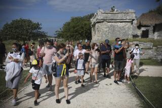
Walk along the dirt road from the primitive Jungle Inn, in the center of the 222-square-mile Tikal National Park, to the Great Plaza. Looming high above the trees are two facing pyramids, eroded by time and weather to a dull gray, but once alive with brilliant contrasting colors--reds and blues and hues of cream.
Marvel at the effort, the talent, the dedication that went into designing and building them and thousands of other structures. Marvel even more at the agility of the Maya priests when you climb the narrow, high-rising, awkward steps. They trod these stones clad in ornate robes, burdened with elaborate headdresses and jeweled ornaments, carrying the weighty staffs and symbols of their high office.
The pyramid at one end of the Great Plaza has been designated Temple I by archeologists, who mapped and reclaimed the six-square-mile center of Tikal from the ravages of the rain forest, and from human predators. A massive stone structure, it is topped by an elaborately carved roof comb that towers 145 feet above the plaza floor.
Facing it across the expanse of the plaza is the Temple of Masks, so-called because of its richly embellished facade. It is almost a matching structure, but a little more squat and massive.
Between them is the plaza floor, four superimposed layers of plaster laid on the limestone bedrock, covering more than 2 1/2 acres. The first of these floors is believed to have been laid in about 150 BC, the top layer in the year 700.
Across the plaza to the right of Temple I is a small ball court, the scene of a game believed to have had great religious significance.
Ritualistic Beheading
The players, clad in protective hip and knee pads, tried to coax a rubber ball through a vertical hoop mounted on the wall without using their hands. Scholars still argue whether it was the captain of the winning or losing team who was ritualistically beheaded.
Positioned on the plaza floor, in rows and groupings, are more than 70 stelae, vertical stone monuments resembling tombstones. Many have matching altars--round, thick, drum-like stones placed flat on the ground. Most are elaborately inscribed with complex hieroglyphics.
As you marvel at the structures, don’t let the massive nature of the pyramids deceive you. When you reach the top of Temple I, the true architectural and engineering genius of the Mayas becomes increasingly apparent.
Number Nine Was Sacred
It’s not just a huge pile of limestone blocks, but a skillfully designed structure with nine terraces (the number nine was sacred to the Mayas), complicated insets, decorative moldings and a stairway from the plaza to the peak. At the top, a building platform supports a three-room temple.
From atop the pyramid, you can look out at the broad expanse of jungle and at the six-square-mile center of Tikal that is partially excavated and restored.
To one side, Temple IV, the highest standing Mesoamerican structure, soars 212 feet from its base to the top of its roof comb. To the right lies the West Plaza, North Acropolis and other groupings of what once were remarkable temples and palaces and plazas. To the left is the temple reservoir, South Acropolis and a complex of structures and ball courts.
In Central Tikal, more than 3,000 constructions--temples, ceremonial platforms, palaces, shrines, residences, causeways and a ritual sweat-bath house--have been mapped and unearthed. As many as 10,000 earlier constructions are believed to underlie the surface, buried by succeeding generations of Mayas and by the encroaching forest.
The Tikal project, begun by the museum at the University of Pennsylvania in 1956, unearthed only the tip of the Tikal iceberg.
Evidence indicates that this land has been occupied by humans since 3,000 BC or earlier, but the Maya civilization began to take form in about 600 BC. It reached its full flower about AD 250, the beginning of what archeologists term the Classic Period. From then until about AD 900 the Mayas engaged in almost ceaseless construction.
Then, for reasons still unknown, the entire complex civilization disintegrated--not with a bang, but with a whimper.
In the early 1950s, expeditions were funded by the Peabody Museum of Harvard and the Carnegie Institution of Washington. Finally, the massive Tikal Project was launched by the University of Pennsylvania in 1956; it continued until 1963.
While the six-square-mile center of Tikal has been mapped and explored, archeologists believe that this great Maya city of 40,000 or more probably extended for at least 25 square miles.
There is still plenty to learn about the Mayas--how they lived and worshiped, what motivated them to develop such scientific and architectural wonders, and how they governed themselves. Scientists have made some progress in deciphering their hieroglyphics and understanding how they recorded dates. Most everything else, however, remains cloaked in mystery.
Perhaps most intriguing, particularly in understanding the potential future of our own society, is how and why this highly sophisticated and complex civilization withered and died.
Slowly Engulfed Other Cities
The Maya civilization started in the southwestern Yucatan Peninsula, then slowly engulfed Palenque and Bonampak in what is now Mexico, Copan in the Honduras, Tikal, Uxmal and Chichen Itza, and finally Tulum at the edge of the sea.
Overnight accommodations are, to put it kindly, primitive: the Jungle Inn offers 14 bungalows, the Tikal Inn has seven, and the Jaguar Inn offers two. Water is neither hot nor potable (except when it comes in bottles), electricity is sporadic, and in the evenings, a strong insect repellent is essential.
For much of the past three decades, U.S. tourists were discouraged from visiting Guatemala, but legitimate free elections were held, a new constitution was adopted and a civilian government voted into office. The U.S. Embassy, in the latest travel advisory, considers the “major tourist attractions” of Guatemala--which include Tikal and Guatemala City, among others--to be free of the threat of violence and thus safe to visit.
Guatemala City is a small but sophisticated city with several good hotels. The best two are probably the 430-room Camino Real-Biltmore, affiliated with the Westin hotel chain, and the 250-room El Dorado.
The exchange rate approximates $1 U.S. to three quetzals, so a deluxe room at the Camino Real-Biltmore, at 90 quetzals, costs less than $30. Be cautious in using bank credit cards. Usually they operate on the basis of a one-to-one exchange rate, which can prove expensive.
Panamundo Guatemala Travel Service in Guatemala City (Ana Smith and her staff speak faultless English) specializes in Tikal tour arrangements. Address: 7A Avenida 14-44, Zona 9, Guatemala City, Guatemala. Phone 011-502-231-3188. Also helpful is Clark Tours, the nation’s largest. Write to P.O. Box 591, Guatemala City, Guatemala or phone 011-502-231-0213.
More to Read
Sign up for Essential California
The most important California stories and recommendations in your inbox every morning.
You may occasionally receive promotional content from the Los Angeles Times.


