Central Coast storm leads to flooding, a water rescue and a wet commute in L.A.

- Share via
A storm system that triggered mudslides as it drenched California’s Central Coast on Sunday marched early Monday toward Los Angeles, where morning commuters were frustrated by wet roadways.
The storm’s strongest cells hit Ventura County after midnight before arriving in L.A., where about an inch of rain could fall, forecasters said. San Luis Obispo and Santa Barbara counties were each expected to get up to 3 inches.
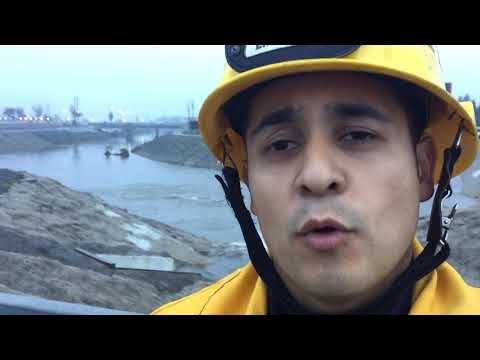
Heavy rain caused flooding in parts of L.A. and prompted at least one water-rescue attempt in the Dominguez Channel in Gardena on Monday morning. Firefighters searched for a missing man for more than two hours after his girlfriend was rescued from the water, according to KABC-TV. Authorities later called off the search and reclassified the case as a missing-person investigation.
Wind gusts of 35 to 50 mph were forecast for the Antelope Valley and Central Coast. A flash flood watch in burn areas in Los Angeles County was canceled around 7 a.m., the National Weather Service said.
Up to half an inch of rain per hour fell in San Luis Obispo County on Sunday night, dumping nearly 5 inches of rain on Rocky Butte, the mountain just east of San Simeon.
About 1.5 inches fell in Cambria, according to the National Weather Service.

Rescue crews were searching the Dominguez Channel in the Gardena area Monday morning after a woman reported her boyfriend had been washed away after entering the channel.
Flooding forced the closure of Highway 1 north of Guadalupe, and a mudslide forced the closure of the highway south of Big Sur from Ragged Point to Lucia, according to Caltrans. Flooding was reported across various roads in San Luis Obispo and Santa Maria.
Authorities in Santa Barbara County have been anticipating heavy rain and flash flooding. The sites of recent fires, such as the Rey and Sherpa fires, could also see debris flows, emergency officials warned.
At the Santa Barbara Municipal Airport, heavy rain late Sunday reduced visibility from 10 miles to 2 miles, according to the weather service.
Further inland, flood advisories have been issued for parts of Kings, Fresno, Kern, Mariposa, and Madera counties, and the advisories were in place until 4:45 a.m. Monday.
After a brief lull, another storm is expected to roll through the Southland on Tuesday night and Wednesday, delivering up to half an inch of rain. That system will bring the potential for snowfall above 6,000 feet. A third storm late Thursday could bring snow as low as 4,000 feet and affect the commute in mountain passes, including Interstate 5 at the Grapevine.
Twitter: @MattHjourno
ALSO
An iconic tunnel tree in a California state park is no more after huge storm
Why construction in downtown L.A. is booming
UPDATES:
9:00 a.m.: This article was updated with information about a rescue being called off.
7:30 a.m.: This article was updated with information about a flood watch being canceled.
6:55 a.m.: This article was updated with information about flooding and future rainstorms.
This article was originally published at 12:10 a.m.
More to Read
Sign up for Essential California
The most important California stories and recommendations in your inbox every morning.
You may occasionally receive promotional content from the Los Angeles Times.


