Lake fire grew after private drone flights disrupted air drops

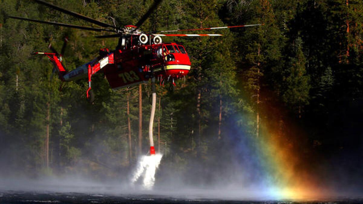
A fire helicopter scoops up water from Jenks Lake as it works to control flames in the Big Bear area.
- Share via
As a hot wind shifted north and drove the flames toward Onyx Peak east of Big Bear Lake, fire crews deployed to save homes scattered among brittle-dry pines — waiting for help from a DC-10 laden with 10,800 gallons of retardant.
It never came. Shortly before 6 p.m. on Wednesday, an incident commander on the ground spotted a hobby drone buzzing near the drop site at 11,000 feet. The air tanker had to turn back, as did two smaller planes following it.
“These folks who are handling these drones, I have to assume they have no idea what they’re doing,” Chon Bribiescas, a spokesman for the U.S. Forest Service, said Thursday. “They not only endangered the folks on the ground, but they endanger the pilots.”
Officials fighting the Lake fire in the San Bernardino Mountains scrambled to warn the public that it is illegal and dangerous to fly drones in restricted airspace around a fire. Unmanned aircraft are particularly hazardous because authorities have no idea who is controlling them or how they might maneuver.
The DC-10 had to divert and drop its retardant on a fire along the Nevada border, while the two smaller planes had to jettison theirs because they couldn’t land with that much weight. Officials said the failed mission cost between $10,000 and $15,000.
As the planes returned to their base by Lake Arrowhead, pilots spotted another drone 1,200 feet above ground, far above the 400-foot limit set by the FAA for unmanned aircraft.
“It’s infuriating,” Bribiescas said.
Authorities could not locate the operators of the drones. They described the aircraft that obstructed the retardant drops as an orange or red fixed-wing drone with a wingspan of 4 feet.
Mike Eaton, forest aviation officer with the U.S. Forest Service, said police would be patrolling mountain roads, looking for people flying drones in the temporarily restricted airspace set by the FAA.
Speaking at a news conference at the San Bernardino Airtanker Base, Eaton urged people to stay away from the fire. Red fliers were stapled around a fire map that read: “If You Fly, We Can’t.”
Eaton said air drops had to be shut down two hours early on Wednesday because of the drone.
“The fire certainly grew because we weren’t able to drop the retardant,” said. “We had to shut down subsequent missions that could have possibly contained the fire.”
By Thursday morning, the fire had grown to 23,199 acres and was 21% contained. Late in the afternoon it had spread a mile north to Heartbreak Ridge.
As unmanned aerial system technology has become more prevalent, so have run-ins between civilians using it and government agencies that consider it a danger. The U.S. Forest Service issued a statement last year on civilian drone use, warning that it could interfere with firefighting efforts.
In July 2014, CalFire crews had law enforcement confront a drone operator near Plymouth in Northern California after he flew the aircraft near a 3,800-acre blaze as crews made water drops.
While it’s illegal for civilians to operate aircraft in restricted space, firefighters are beginning to use drones for their own purposes.
The U.S. Forest Service requested a drone from the Department of Defense in 2013 to help survey the Rim fire, one of the largest blazes in state history. The drone helped map where the fire was going and kept track of crews at night.
This week in the San Bernardino National Forest, firefighters have focused on containing the blaze south of Highway 38 in the San Gorgonio Wilderness area, preventing it from climbing up the mountainside behind the Snow Summit and Bear Mountain ski resorts and threatening the communities around Big Bear Lake.
The fire sent a massive plume of smoke northeast, blanketing much of southern Nevada and the eastern edge of California.
John Miller, another Forest Service spokesman, said conditions for the next few days look dicey. Sporadic winds from incoming storms, as well as lightning, could potentially trigger more wildfires.
And he said the dry conditions from the drought are causing the fire to burn differently. Normally, large trees slow fires down, but because they are so parched, they are burning fast, more like hillside chaparral.
“What this fire is showing us is that this is not a normal fire season,” Miller said. “There is nothing normal about the way the fuels are burning and are being consumed.
“We’re seeing fire activity above 10,000 feet that we haven’t seen in years.”
Mandatory evacuations were in effect for the high desert communities of Burns Canyon and Rimrock, northeast of the fire.
Firefighters were trying to persuade residents of Burns Canyon to leave, even though the vegetation — and potential fuel load — is much sparser.
The dusty area is served by a single narrow road. If the fire made a turn toward the community, a flat tire could stop others from getting out.
A couple of miles east in Rimrock, residents decided to stay put among the Joshua trees, despite the billowing cloud of white smoke that gathered not too far in the distance.
Some soaked their roofs and packed their trucks, just in case.
Norm Erickson, 59, sat outside monitoring the fire and made sure that 4,000-gallon water tanks were filled for firefighters. The 30-year resident of this quiet community said he hadn’t expected the blaze to get close to his neighborhood.
“It was on the other side of the mountain,” he said. “I didn’t think they’d let it get that far, though it’s pretty inaccessible terrain they’re working with.”
He said he had been surprised when he heard someone had flown a drone into the fire area. If the blaze continued to burn out of control, Erickson said, “they’ll be responsible for it.”
In the mountains just outside of Big Bear, the San Bernardino County Sheriff’s Department advised residents in Lake Williams, Erwin Lake and Baldwin Lake to be prepared to evacuate.
But in town, life moved along at its normal languid summer pace.
“It sounds like firefighters have it under control,” said Judy Houston, working at the Gold Rush Resort in Big Bear Lake.
She said she’s been getting fire updates through Facebook and other websites, and isn’t worried about the shifting winds expected this weekend.
“The storms could be a blessing,” Houston said. “If they’re anything like the monsoon storms we get, then it could bring a good downpour.”
Serna and Mozingo reported from Los Angeles, Esquivel from Rimrock. Times staff writers Ruben Vives in Big Bear Lake and Veronica Rocha in Los Angeles contributed to this report.
For more California fire news, follow @JosephSerna
ALSO:
Mono Lake’s ecological crisis is a blow to wildlife, L.A. water supply
Water conservation amid drought: Who made the grade?
Santa Barbara’s cautious relationship with water offers a drought lesson
More to Read
Sign up for Essential California
The most important California stories and recommendations in your inbox every morning.
You may occasionally receive promotional content from the Los Angeles Times.


