Another toll of the drought: Land is sinking fast in San Joaquin Valley, study shows
- Share via
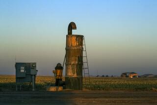
Farmland near Corcoran in the southern San Joaquin Valley sank 13 inches in just eight months last year. To the north, near El Nido, the land surface dropped about 10 inches.
Along a major canal near Los Banos, the ground has sunk so much that the concrete sides cracked. Nearby, a bridge over another canal had dropped so low it had to be demolished and replaced with a higher structure.
Groundwater over-pumping is causing some parts of the San Joaquin Valley to sink faster than ever, according to a NASA report released Wednesday.
The survey dramatically documents the rising toll the prolonged drought is taking on the Central Valley, where some federal irrigation deliveries have been cut to zero, domestic wells have run dry and growers are drawing down portions of the valley’s vast aquifer to historic lows.
Water and Power is The Times’ guide to the drought. Sign up to get the free newsletter >>
To keep their fields green, they have drilled new and deeper wells and ramped up withdrawals, worsening the valley’s historic problem of land subsidence and depleting their water savings account for future droughts.
The sinking is so subtle that it is imperceptible on the ground, save for the effect on infrastructure. Aqueducts and irrigation canals buckle. Roads crack, causing millions of dollars worth of damage.
The NASA figures, based on radar data from satellites and aircraft, underscore the unsustainable levels of groundwater use in the San Joaquin Valley. Even in wet times, farmers in parts of the valley pump more from the region’s deep aquifer than is replenished.
California’s new groundwater law calls for local agencies to end that chronic over-pumping and balance aquifer withdrawals with water that man or nature puts back. But the requirements won’t take full effect for more than two decades.
“There’s no doubt these sorts of effects are going to continue to some extent,” said Mark Cowin, director of the state Department of Water Resources, which commissioned the report. “I don’t think we can end overdraft and subsidence overnight.”
Cowin nonetheless cited the NASA figures as reason for counties to move quickly and adopt local pumping limits in overdrafted basins. “There’s more to be done in the near term,” he said. “We need to press for action ahead of the schedules.”
He added that the state was “not ready to prescribe to counties exactly what they should do at this point.”
The NASA results are based on comparisons of surface land changes recorded by satellite and aircraft radar equipment.
They show main areas of recent subsidence in the San Joaquin Valley — one bowl near El Nido that is some 25 miles in diameter and a larger one that extends for 60 miles in the Corcoran area. From 2006 to 2010, the land surface south of El Nido sank about two feet and the ground near Corcoran dropped about three feet.
The subsidence accelerated in 2014, when the land around Corcoran fell at a rate of about 1.6 inches a month and the ground south of El Nido dropped slightly more than an inch a month.
Groundwater levels have dropped to new lows in some parts of the San Joaquin Valley as agriculture has turned in a big way to wells to make up for drought-related cuts in irrigation deliveries. “We’re pumping at record levels,” said Cowin, adding that he was not surprised by the subsidence.
Not all of it is caused by drought-related pumping. Near El Nido, scientists with the U.S. Geological Survey who are monitoring the area say much of the groundwater is being used to irrigate new nut groves expanding into areas that weren’t previously irrigated and have no access to surface deliveries.
The Central Valley aquifer extends for about 400 miles under the Sacramento and San Joaquin valleys. The subterranean water, some of which seeped into the ground 10,000 to 20,000 years ago, is California’s biggest reservoir. Yet it has been largely unregulated and unmonitored. Most of the pumping is by agriculture, but the state doesn’t have good figures on how much is being withdrawn or by whom.
Subsidence occurs when water withdrawals compact the soil, permanently shrinking the space between clay particles. Even if the water table recovers, subsided basins can’t hold as much water as they did previously, reducing the aquifer’s capacity.
When the land sinks unevenly, roads and irrigation canals can buckle, causing serious damage.
The satellite data showed surface drops along short portions of the California Aqueduct, which carries supplies from Northern California to the San Joaquin Valley and Southern California.
The subsidence increased dramatically between June and October 2014, when one area along the aqueduct fell eight inches.
The state has repaired the aqueduct’s berms in the past, Cowin said, but he did not have up-to-date figures on the cost.
Even if such drops don’t crack the sides of irrigation canals, they can slow water movement.
State water officials on Wednesday also released an updated list of the most severely overdrafted groundwater basins, showing where California’s groundwater crisis is most acute.
The vast majority stretch from Merced to Bakersfield in the San Joaquin Valley. But five of the basins that officials described as “in trouble” are in Southern California, including aquifers beneath parts of Oxnard, the Cuyama Valley near Santa Barbara and the Indian Wells Valley north of Lancaster.
Times staff writer Matt Stevens contributed to this report.
Twitter: @boxall
ALSO:
Massive Rocky fire was sparked by faulty water heater, investigators say
Former L.A. sheriff’s captain is expected to plead guilty in jail scandal
Steve Lopez: Pizza maker burns time and dough on red tape
More to Read
Sign up for Essential California
The most important California stories and recommendations in your inbox every morning.
You may occasionally receive promotional content from the Los Angeles Times.


