California’s catastrophic year of wildfires worsens with Redding destruction

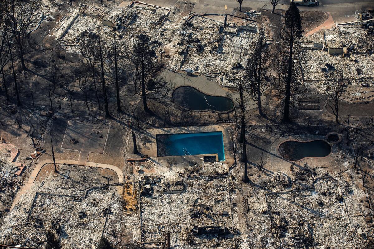
The Carr fire destroyed an untold number of homes in Shasta County Thursday night.
- Share via
California’s grim year of fire destruction just got worse.
The Carr fire, which has destroyed countless homes in Redding and killed at least two people, is the latest inferno to spread from wildlands into urban areas, fueled by extreme heat and winds.
Last fall, Northern California’s wine country was hit by the most destructive fires on record, destroying thousands of homes and killing dozens of residents. In December, the Thomas fire tore through Ventura and Santa Barbara counties, becoming the largest single fire in state history.
So why has the last year been so bad? Here are some answers from the pages of The Times:
What do we know about the risk?
The combination of heat and winds has long been the key factor for fires in California. But much of the state has seen record low rains and drought conditions for several years, making the situation worse.
The danger often is the greatest in areas where open space gives way to development.
Over time, the edges of cities have encroached on wild spaces. The close proximity between private property and wildlands allows fires to spread more rapidly and damage or destroy more property in the process.
Many of these at-risk areas are in wildland-urban interface areas, or WUIs — where housing and vegetation intermix or come within close proximity of each other.
The Carr fire in Shasta County was burning in rural areas, but on Thursday, it crossed the Sacramento River and pushed into suburban tracts on the edge of Redding in Northern California.
The patterns were similar in the wine country and Thomas fires.
What can we learn from California’s biggest fire?
The Thomas fire became California’s largest by size since modern record-keeping began. It raced from the urban edge to deep into the Los Padres National Forest like no fire before, covering huge distances unobstructed and mostly unseen. The neighborhoods and cities that sit at the foot of these steep ranges — the Santa Ynez, Topatopa and Sierra Madre — had no vantage to the immense wilderness beyond the first ridge or two, no real grasp of what was seething out of sight.
The fire then came over those ridges — again and again — eating homes across a 55-mile swath of civilization.
A blob of high pressure, shifting back and forth, changed the direction of the air flow as it fought with the prevailing sea breeze, constantly pushing the Thomas fire into new territory and keeping it going for weeks.
What was previously California’s largest modern-era blaze, the Cedar fire in San Diego County in 2003, followed a more typical Santa Ana pattern, racing to the coast through canyons running roughly westward.
It was far more deadly and costly than the Thomas fire because the gentle tilt of San Diego County invited more development into the fire zone. The Cedar’s toll was 15 people and 2,820 structures.
Despite its size, the Thomas fire claimed only 1,063 structures and one firefighter’s life. The terrain it consumed was more rugged, most of it protected or prohibitively steep to build on.

How about the wine country fires?
Those fire also were fueled by unusually powerful weather conditions.
Driven by hot, dry winds blowing a sustained 50 mph, the Tubbs fire — one of the most destructive of the wine country blazes — chewed across a small mountain range in a few hours on the night of Oct. 8 and roared into northeastern Santa Rosa.
Officials estimated the city of 177,000 lost nearly 3,000 homes, or roughly 5% of its housing stock. Even big-box stores and a Hilton hotel next to Highway 101 went up in flames.
Hot, dry winds from the interior are not uncommon in Northern California. The Bay Area’s version of the Santa Ana winds are called Diablo winds, the kind that drove the 1991 Tunnel fire in the Oakland hills, leaving 25 dead and leveling 2,900 buildings.
But in the grim record of the state’s worst wildfires, that was an outlier.
Until last week, 13 of the 20 most destructive wildfires in modern state history — and 16 of the 20 deadliest — occurred in Southern California.
What about climate change?
Gov. Jerry Brown and many others have argued fires are getting worse because of climate change.
Surveying the Thomas fire in December, Brown called it “the new normal,” declaring: “This could be something that happens every year or every few years.”
A study earlier this year found that Californians should expect more dramatic swings between dry and wet years as the climate warms.
UC researchers in essence found that California’s highly volatile climate will become even more volatile as human-caused climate change tinkers with atmospheric patterns over the eastern Pacific Ocean.
The state veered from years of record-breaking drought that emptied reservoirs and prompted unprecedented urban conservation to a parade of atmospheric rivers that dumped record precipitation on Northern California during the 2016-17 rainy season.
Portions of the main spillway at Lake Oroville, the state’s second-largest reservoir, collapsed, and the state narrowly escaped a dam disaster that would have sent a wall of water roaring through downstream towns.
Such sudden swings between severe drought and intense storms will increase the threat to aging dams and flood-control networks, accentuate the threat of wildfires and make management of the state’s complex waterworks even more daunting.
More to Read
Sign up for Essential California
The most important California stories and recommendations in your inbox every morning.
You may occasionally receive promotional content from the Los Angeles Times.


