Ocean temperatures are off the charts, and El Niño is only partly to blame

- Share via
In a world of worsening climate extremes, a single red line has caught many people’s attention.
The line, which charts sea surface temperatures in the North Atlantic Ocean, went viral over the weekend for its startling display of unprecedented warming — nearly 2 degrees (1.09 Celsius) above the mean dating back to 1982, the earliest year with comparable data.
Ocean temperatures are so anomalously high that Eliot Jacobson, a retired mathematics professor who created the graph using data from the National Oceanic and Atmospheric Administration, had to “increase the upper bound on the y-axis,” he said.
“I’ve been doing this for a long time, but this one was like, ‘Oh my God, look at this,’” Jacobson said of the graph. “What is going on here?”
He and other researchers said there are several factors that may be contributing to the off-the-charts warming, which is occurring alongside other climate woes including record-shattering wildfires in Canada, rapidly declining sea ice in Antarctica and unusually warm temperatures in many parts of the world, not including Southern California.
Underlying everything is human-caused climate change, said Daniel Swain, a climate scientist at UCLA.
But atop that are a handful of other potential factors, including the early arrival of El Niño; the recent eruption of the Hunga Tonga volcano; new regulations around sulfur aerosol emissions or even a dearth of Saharan dust.
“The North Atlantic is record-shatteringly warm right now,” Swain said during a briefing Monday. “There has never been any day in observed history where the entire North Atlantic has been nearly as warm as it is right now, at any time of year.”
There is an 84% chance the system will be of moderate strength, and a 56% chance it will become a strong event at its peak, forecasters said.
Nearly all of the Atlantic basin is experiencing anomalous warmth, including the Irminger Sea southeast of Greenland, the western Mediterranean Sea, and the tropics “all the way from Africa to at least the Caribbean,” said Gregory Johnson, an oceanographer at NOAA’s Pacific Marine Environmental Laboratory.
“We are definitely in record territory,” Johnson said.
And it’s not just the Atlantic, as global sea surface temperatures are also climbing to new highs, NOAA data show.
Such warming events can have considerable consequences, including triggering algal blooms, bleaching coral and negatively affecting fisheries and other ecosystems, Johnson said.
Marine heat waves can also provide more energy for tropical cyclones and more moisture for atmospheric rivers and flooding events. And a warmer ocean tends to expand, which can lead to sea level rise along with melting ice sheets.
“This is part of a long-term trend,” Johnson said. “If greenhouse gases continue to accumulate in the atmosphere, we’re going to continue to break records in terms of global average temperatures — whether it be sea surface temperature, or sea and land, or land alone. I think it’s having big impacts, and it’s something that we have to pay attention to.”
The recent arrival of El Niño, a climate pattern in the tropical Pacific and a major driver of weather patterns across the world, could be partially to blame, Johnson and others said. While its counterpart, La Niña, brought cooler water to the ocean’s surface, El Niño is generally linked to warmer global temperatures and often results in warmer oceans.
NOAA recently said there is an 84% chance that the developing El Niño will be of moderate strength, and a 56% chance it will become a strong event at its peak later this year.
Meanwhile, the World Meteorological Organization predicts that at least one of the next five years — and the five-year period as a whole — will be the Earth’s warmest on record due to global warming and El Niño.
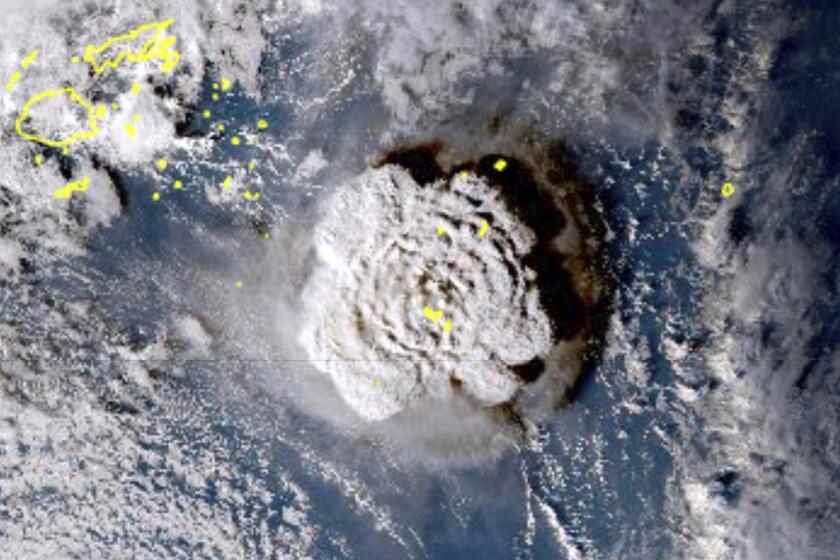
An undersea volcano in Tonga shot millions of tons of water vapor into the atmosphere, which might warm the Earth’s surface over the next few years.
But El Niño doesn’t entirely explain the sudden escalation in ocean temperatures. Another potential factor may be the recent eruption of an undersea volcano in Tonga, said Swain.
The volcano, Hunga Tonga-Hunga Ha’apai, erupted beneath the ocean in January 2022 and shot record-breaking amounts of water vapor all the way up to the stratosphere. And because water vapor acts as a heat-trapping greenhouse gas, researchers said the eruption could result in more planetary warming.
“We now have a natural volcanic event that, somewhat amazingly, is probably resulting in an additional short-term window of global warming,” Swain said. “That’s on top of the human-caused warming that we’re already seeing, so that may be part of why we’re seeing such a spike right now in some global ocean temperatures and in global atmospheric temperatures.”
Meanwhile, a major change in regulations around the sulfur content of shipping fuels could also be behind the warming spike, according to both Swain and Jacobson.
The regulations, ordered by the International Maritime Organization in 2020, reduced the upper limit of sulfur in fuels from 3.5% to 0.5% in an effort to achieve cleaner air in ports and coastal areas.
However, the change may have had an unexpected consequence because sulfate aerosols can reflect sunlight away from the earth, “effectively dimming the planet’s surface,” Jacobson wrote in a post on his website.
“By cleaning up shipping fuels, massive regions of the world’s oceans that were protected from heating by shipping sulfate aerosols are now experiencing rapid warming,” he said, including many of the main shipping routes where the warming is happening.
Swain shared a similar hypothesis, noting that though global shipping has largely returned to baseline levels after declining during the COVID-19 pandemic, there remains a huge drop in sulfur emissions.
“It is being speculated that this is part of the reason why we’re seeing such record-breaking global ocean temperatures and atmospheric temperatures right now,” he said.
“Now that we’ve eliminated at least a significant portion of that offsetting effect, we may have somewhat unintentionally unearthed an additional component of this warming,” he added.
Southern California can expect another week of June gloom, with a chance of thunderstorms and showers on the horizon.
Michael Mann, a professor of earth and environmental science at the University of Pennsylvania, said while sulfate aerosols can influence the North Atlantic, he did not believe that the recent regulatory change is behind the current temperature spike.
Instead, he said, a lack of Saharan dust — possibly linked to weakened trade winds from the burgeoning El Niño — could be impacting temperatures on short timescales. The dust normally has a cooling impact on the area, and the lack of dust “probably does help to explain the observed anomaly.”
“The primary cause of the warming we are seeing right now is an El Niño event on top of overall human-caused warming,” Mann said.
Interestingly, one of the few areas not experiencing unusual warmth right now is Southern California, which has been unseasonably cool and cloudy for several months on end.
While that may be a response to El Niño, it could also be driven by the same persistent wave patterns that are contributing to the Canadian wildfires, record-breaking warmth in Western Europe and Southeast Asia, and flooding in parts of the Mediterranean, Swain said.
Though concerning, the conditions aren’t “completely out of left field” based on global warming trends, Swain said.
“The long-term trend is not going to stop, and we are stair-stepping up our way to much warmer oceans and a much warmer climate, and there still hasn’t been a great deal of momentum away from that,” he said. “We’re still moving in a pretty alarming direction, overall, when it comes to warming.”
More to Read
Sign up for Essential California
The most important California stories and recommendations in your inbox every morning.
You may occasionally receive promotional content from the Los Angeles Times.


