With severe drought, an urgent call to rework the Colorado River’s defining pact

- Share via
One hundred years after a landmark agreement divided the waters of the Colorado River among Western states, the pact is now showing its age as a hotter and drier climate has shrunk the river.
The flow of the Colorado has declined nearly 20% since 2000. Reservoirs have dropped to record low levels. And despite a series of deals among the states to temporarily take less water from the river, the shortage continues to worsen.
Former Interior Secretary Bruce Babbitt, who oversaw management of the river under President Clinton, said it’s become clear that the 1922 Colorado River Compact should be revamped to adapt to the reduced amount of water that is available as global warming compounds the 22-year megadrought in the watershed.
Babbitt said that a few years ago, he had thought the seven states could get by while leaving the agreement unchanged. But the Colorado River Basin has been drying out so rapidly with rising temperatures, he said, that the pact should be updated to allow the states to proportionally scale back their water use to deal with what scientists describe as the aridification of the West.
“While I once thought that these aridification scenarios were kind of abstract and way out in the future, I don’t think that anymore,” Babbitt said in an interview with the Los Angeles Times. “It’s absolutely urgent that we start thinking now, while there’s time, about how we adjust the compact, the regulations, the necessary reductions, in the most careful way so that we limit the damage, which can really be extreme.”
After hours of intense debate Thursday, coastal regulators have rejected Poseidon Water’s proposal to build a desalination plant in Huntington Beach.
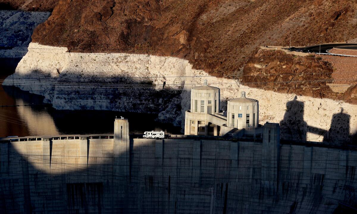
The levels of Lake Mead and Lake Powell, the nation’s largest reservoirs, have dropped to their lowest point since they were filled.
Representatives of California, Arizona and Nevada signed an agreement in December to take less water from the river over the next two years. But the latest projections from the federal government show that larger cuts will take effect next year as Lake Mead continues to decline.
Managers of water agencies have said the continuing downward spiral in reservoir levels shows that the entire region, from the Rocky Mountains to the U.S.-Mexico border, will need to devise bigger steps to reduce water use. But many of those who manage water supplies have expressed a reluctance to rewrite the Colorado River Compact, which laid down the foundational framework that has become the law of the river.
“The basic issue is how do you manage a river to balance inflow with diversions, what you take out? It’s a simple balance equation,” Babbitt said. “We must reach water balance, cut diversions down to the level, which on a short-term average is the amount of water coming in. You’ve got to balance the water coming in, water going out.”
Babbitt said problems in the Colorado River Compact include how it was written, based on assumptions of much larger flows, and how certain provisions become unworkable under such dry conditions.
As parts of Southern California fall under new water restrictions, other regions offer lessons in how to shrink water use and adapt to drier times.
The 1922 agreement divided the water among four states in the river’s Upper Basin (Colorado, Wyoming, Utah and New Mexico) and three states in the Lower Basin (Arizona, Nevada and California), with the dividing line between the two basins drawn at Lees Ferry, just upstream from the Grand Canyon. Separately, a 1944 treaty established how much water Mexico would receive.
The way the compact divided the river, splitting 15 million acre-feet between the Upper Basin and the Lower Basin states, is now colliding with the reality that the river’s average yearly flow since 2000 has been about 12.3 million acre-feet.
“With the onslaught of drought and the aridification as a result of climate change, those numbers aren’t working,” Babbitt said.
One big reason they no longer work, Babbitt said, is that the century-old agreement includes a provision requiring the Upper Basin states to deliver 7.5 million acre-feet per year to the Lower Basin, the largest share of which goes to California. The Upper Basin states face future scenarios in which they would be required to make huge and disproportionate reductions in water use, Babbitt said.
“That’s going to have to be dealt with. And that means that the compact itself is going to have to be renegotiated to put a little more balance into who bears the brunt of the reduced flows,” Babbitt said.
Citing extreme drought, the government has announced reduced water releases from Lake Powell and Glen Canyon Dam by nearly half a million acre-feet.
Water from the Colorado River is used by about 40 million people, flowing to cities, farmlands and tribal nations from the Rocky Mountains to Southern California. The river has long been overused. So much water is diverted that the river’s delta in Mexico largely dried up decades ago.
To cope with the river’s decline, officials representing the seven states have sought to work through consensus-building, avoiding conflicts by negotiating temporary deals for sharing water reductions while keeping the century-old system of allocating water. They are dealing with the shortage under temporary rules adopted 2007, as well as a short-term deal called the Drought Contingency Plan that was signed in 2019. They will need to negotiate new rules for handling shortages by 2026, when the current rules expire.
“We can no longer just kind of muddle along. We really have to think big, because we’re going to have to create a new regulatory framework. And it doesn’t mean that we have to start over from scratch,” Babbitt said. “The Colorado River Compact has worked for 100 years. But there is now a future scenario in which the fixed delivery obligation — from the Upper Basin states at Lees Ferry to California, Arizona and Nevada — simply doesn’t work.”
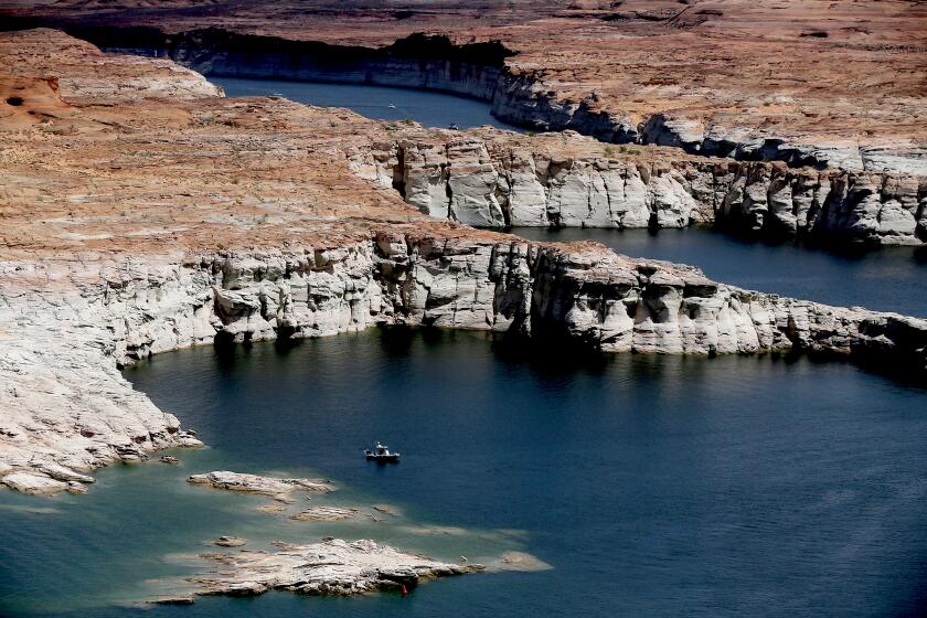
Lake Powell, the second-largest reservoir on the river, has declined to just 25% of full capacity. The federal government, trying to reduce the risk of the lake reaching critically low levels at Glen Canyon Dam, has announced that is holding back additional water in the reservoir this year.
“The compact will have to be adjusted to say, at some point, further river declines due to drought must be shared equitably across both basins in a kind of proportionate basis,” Babbitt said. “We’re not going to rewrite the whole thing. We’re not going to advocate a great revolution or some other methodology for running the river.”
“Everybody has got to acknowledge that at some point, we’re all going to share the shortage up and down the basin everywhere, in equitable fashion. We’ll all take a proportionate hit,” he said.
Babbitt was Arizona’s governor from 1978 to 1987 and was secretary of the Interior from 1993 to 2001. Now 83, Babbitt remains engaged in issues such as advocating for preservation of water supplies, protection of wilderness and action on climate change.
Babbitt has witnessed a stark transition on the Colorado River over the last four decades. In 1983, when he was Arizona’s governor, the flooding river filled Lake Powell and came within inches of overtopping Glen Canyon Dam.
As Interior secretary in the 1990s, Babbitt worked on developing rules for handling the “surplus” water that was coming down the river. After those rules for handling surplus water were completed, the Colorado River Basin plunged into drought in the early 2000s.
Scientists studying ancient records in tree rings have found that the current megadrought in western North America, from Montana to California to northern Mexico, has become the region’s driest 22-year period in at least 1,200 years and is intensifying as accumulating greenhouses gases push temperatures higher.
In other research, scientists have studied how much more the river could shrink as temperatures rise, projecting that for each additional 1 degree Celsius (1.8 degrees Fahrenheit) of warming, the average flow is likely to drop about 9%.
In a study published last month, scientists at Los Alamos National Laboratory projected that climate change will bring large losses of snowpack in the Rocky Mountains, where much of the river’s flow begins as melting snow and rain. The researchers found that areas in Colorado, Utah and Wyoming could see a major reduction in water resources in the future and that conditions in the Upper Basin could become more like the arid Southwest.
“We’re really seeing this being a much more water-limited future,” said Katrina Bennett, a hydrologist and co-author of the study. “We are losing our snowpacks. It is getting more arid. And we are likely to see that signal continue. But as long as we can understand it, then we can plan for this and work on this problem together.”
Babbitt said tweaking the 1922 Colorado River Compact to update it would help deal with the situation and enable the seven states to better address the “structural deficit,” the imbalance between water supplies and demands that has sent reservoirs dropping to new lows.
He said the latest plan by Arizona, California and Nevada to take less water from Lake Mead, facilitated partly by paying some entities to reduce water use, is only “delaying the crisis.” The temporary deal aims to keep an extra 1 million acre-feet of water in the lake in 2022 and 2023.
Meanwhile, Lake Mead continues to decline.
“The fact is that there is way too much water being diverted,” Babbitt said. “You’ve got to balance the water you take out to the amount of water that the river’s bringing in.”
More to Read
Sign up for Essential California
The most important California stories and recommendations in your inbox every morning.
You may occasionally receive promotional content from the Los Angeles Times.


