High Winds Damage Homes as Storm Strikes Dana Point
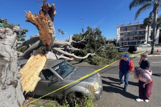
A fast-moving storm off Orange County early Thursday brought powerful winds onshore near Dana Point, damaging a beach house and several mobile homes.
ŌĆ£It was like a swoosh and growl,ŌĆØ said Elizabeth Lynch, a resident of Beechwood Village Mobile Home Park on Doheny Park Road, where the winds toppled several trees, shattered windows, ripped awnings and collapsed a carport. ŌĆ£It sounded like moving thunder.ŌĆØ
Lynch, 40, said she tried to leave her home through the garage but returned to her bedroom after realizing that she couldnŌĆÖt open the door. ŌĆ£After it was all done,ŌĆØ she said, ŌĆ£I came out and couldnŌĆÖt believe what I saw: My carport was completely crushed.ŌĆØ
The winds also scattered the roof tiles and blew out windows of an oceanfront house in Capistrano Beach.
No injuries were reported.
The California Highway Patrol reported 108 accidents in the county from midnight to noon -- about triple the number recorded on an average day.
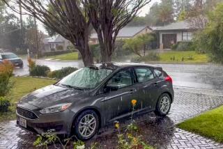
Most areas of the county received between a half-inch and 1.2 inches of rain from midnight Wednesday through Thursday morning, the National Weather Service reported. That was slightly less than in downtown Los Angeles, where about an inch of rain snarled early traffic and nudged the city closer to the all-time rainfall record that has stood for 121 years.
The National Weather Service said the 1.02 inches of rain that fell on downtown Los Angeles raised the total for the season -- which runs from July 1 through June 30 -- to 37.06 inches, just 1.12 inches short of the record of 38.18 inches set in 1883-84.
But breaking that record isnŌĆÖt assured. To do so, downtown Los Angeles needs an additional 1.13 inches by the end of June; normally the city gets only about a quarter of an inch of rain during that period.
ŌĆ£I know IŌĆÖm sticking my neck out, but I have a strong feeling that weŌĆÖre going to smash that record,ŌĆØ Bill Patzert, a meteorologist at the Jet Propulsion Laboratory in La Canada Flintridge, said Thursday.
Patzert said the fact that this rainy season was in second place was remarkable considering the lack of El Nino, the oceanic-meteorological phenomenon that brings heavy rain to Southern California.
ŌĆ£This winter has broken all the rules,ŌĆØ he said.
ŌĆ£WeŌĆÖre still in a winter weather pattern, and all we need is one or two small storms like ThursdayŌĆÖs and weŌĆÖll get that record.ŌĆØ
ThursdayŌĆÖs storm was a ŌĆ£classicŌĆØ cutoff low, a system that dropped out of the normal storm track to the north and stalled off the coast, picking up moisture before moving onshore.
The heaviest rain fell between about 4 and 7 a.m., tapering off to scattered showers that petered out by midafternoon.
Storm totals by nightfall Thursday included 2.24 inches at Santa Paula Creek in Ventura County, 1.54 at the Sepulveda Pass in the Santa Monica Mountains, 1.26 at Refugio Pass in Santa Barbara County, 1.22 at the Hotel Bel-Air, 1.19 in Burbank and 1.12 in Long Beach.
Caltrans had to call in a skip loader to remove debris after a multiple-vehicle pileup on the Santa Monica Freeway east of downtown.
Standing water closed lanes on the Long Beach Freeway in Long Beach for 90 minutes as well as a stretch of the Santa Ana Freeway in downtown Los Angeles for about 45 minutes.
CHP Officer David Porter said that no matter how many warnings were issued, drivers tended to forget how dangerous rainy weather could be. ŌĆ£People need to be constantly advised to slow down,ŌĆØ he said.
Times staff writers Eric Malnic in Los Angeles and Mai Tran in Orange County contributed to this report.
More to Read
Sign up for Essential California
The most important California stories and recommendations in your inbox every morning.
You may occasionally receive promotional content from the Los Angeles Times.


