An âAtlantisâ Rises from the Desert
ST. THOMAS, Nev. â Jerry Phillipeck and his family zipped around Lake Meadâs St. Thomas cove on boats and water skis for 20 years, never realizing they were playing above a desert Atlantis.
This year, with a Western drought dropping the vast reservoir behind Hoover Dam to its lowest level since the mid-1960s, Phillipeck left the boat on the trailer and led a family trek to the dusty remains of old St. Thomas -- a Mormon community flooded in the 1930s to slake the thirst of the Southwest.
DâArynne Phillipeck, 18, clutched her baseball cap to her head against a blast-furnace August wind and described the foundation of a house and a drinking-water cistern they found amid tree stumps and fast-growing tamarisk brush.
At waterâs edge, a crumbling chimney marked the site of a ghostly ice cream parlor.
âWhen we were water-skiing we were 70 feet over someoneâs house,â said her dad, Jerry Phillipeck of Simi Valley, Calif.
Verna Chadburn Heller, 84, grew up in one of those homes. She remembers the ice cream parlor, which was Reinhold Hannigâs place.
âWe didnât any of us have any money,â said Heller, who was entering eighth grade when her family of 10 moved from St. Thomas to Springville, Utah. âBut everyone cared for everyone else. It was like one big family.â
St. Thomas survived 73 years before being sacrificed to progress when Hoover Dam was completed in 1935 and water began filling Lake Mead, the nationâs largest man-made reservoir.
The town had been settled in 1865 by Mormons led by Thomas Smith -- dispatched by Brigham Young to plant cotton along the Muddy River.
Almost 500 people lived there when the town dependent on water was told it would be destroyed by water.
Leland Whitmore postmarked the last letter from St. Thomas on June 11, 1938, and tossed the last sack of mail into a boat at the post office doorstep.
Hugh Lord waited a little longer.
âHe said the lake would never reach him,â said Virginia âBeezyâ Tobiasson, 58, historian for the surrounding Moapa Valley and Hellerâs daughter-in-law. âHe said he was going to stay in his house.â
Tobiasson pores over maps, ledgers and journals at an old schoolhouse library in nearby Logandale. She has a photograph of Lord stepping from his porch onto a rowboat before setting his home ablaze.
âHe torched the houseâ when he realized it would be inundated, she said.
In the three years it took for the lake to reach 45 miles upstream to the confluence of the Muddy and Virgin rivers, the Army Corps of Engineers dismantled or moved town buildings, cut the mock orange trees lining Main Street and exhumed the dead from the town cemetery -- reburying the bodies in Overton, eight miles up the road.
âSt. Thomas was a close-knit family town,â Tobiasson said. With waters receding and interest peaking, she plans to squeeze 30 years of oral, written and photographic history into a 225-page book.
Her work has an added urgency: The number of surviving town residents has dwindled to fewer than two dozen.
The town was famous for cantaloupes, she said. Every family had at least one milk cow and a grape arbor. They dried grapes for raisins and grew apricots, peaches, almonds, pomegranates, asparagus and figs.
âThey had access to water from the Muddy,â she said. âIt was just a creek then.â
These days, the National Park Service says the site, within Lake Mead National Recreation Area, gets 300 visitors on weekend days. It is accessible from the bluff promontory at the end of a 3.4-mile washboard dirt road off state Highway 169.
Determined scavengers surreptitiously scour the site with metal detectors, and rangers fret that people are making off with teacups, bricks and other artifacts.
âWe want people to be able to go there and see this town frozen in time,â spokeswoman Roxanne Dey said. âBut we are having a problem with treasure hunters out there.â
âYou see little holes all over the place,â said Steve Daron, a Park Service archeologist who plans to post interpretive signs telling tales of St. Thomas and encouraging people to leave it untouched.
âThe more people who know about and appreciate the town, the more theyâll want to help us protect it for the future,â he said.
Dey said rangers have issued 13 summonses in 2003 for preservation-law violations and illegally using metal detectors in a national park. A misdemeanor can bring a $500 fine and six months in jail, she said, and a conviction on a felony charge could mean a $10,000 fine and 10 years in prison.
Looting wasnât considered a problem when St. Thomas resurfaced during an earlier drought in 1952, nor in the early 1960s, when the Lake Powell reservoir was being filled upstream on the Colorado River.
Heller visited then and found a shiny $5 gold piece in the old wagon yard. She recognized the school by its fallen arches and hint of stairs, and the Gentry Hotel by its sheer size.
She wonât visit this year, she said. Sheâs getting too old.
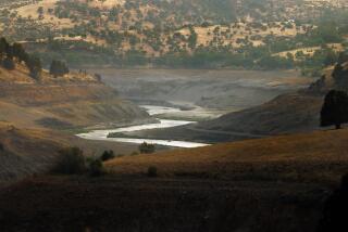
St. Thomas is exposed because Lake Meadâs surface has dropped 72 feet since January 2000 -- leaving a bathtub ring of mineral white on more than 700 miles of rocky shoreline and raising concerns about the drinking water supply for Las Vegas.
âItâs telling us a story about change in the desert and how people adapted,â said Michelle Riter, a National Park Service ranger who has researched St. Thomas.
She imagines farmers going to church and the rodeo, children picking R.O. Gibsonâs front-yard cherry tree clean, eight-horse teams clattering down dusty Main Street hauling heavy copper ore from the Grand Gulch mine 30 miles away. Tiny Las Vegas, with 5,165 residents, was a torturous 70 miles of bad road away.
She hears a story of âboom-and-bust and life-and-death in the desert Southwest.â
âIf you listen closely, you might hear about our own mortality,â she said.
Officials say that if drought persists, the lake could drop 14 more feet by next summer, to 1,129 feet above sea level. It would still be more than half full, about 500 feet deep at the dam, and contain about 4.6 trillion gallons of water. Water intake tunnels that supply the Las Vegas area are at 1,050 feet and 1,000 feet.
St. Thomas had no plumbing, no electricity, no refrigeration, no air conditioning.
âNothing to make it easy,â said Heller, who now lives in a doublewide mobile home on an acre of land with shady fruit trees in Logandale.
âWe took water out of an irrigation ditch with buckets and ran it through charcoal into a barrel out next to a tree,â she said. âCooling was out under an arbor in the backyard. We slept outside until almost Thanksgiving, it was so warm.â
Heller recalled bouncing with other barefoot kids in an open-sided bus eight miles up the road to Overton to see black-and-white picture shows. She milked cows and churned butter with her mother to sell to miners -- and then to the surveyors who came to town to scout sites for Hoover Dam.
She had nightmares about a wall of water swamping her two-story home. But when the water did come, it rose steadily, not all at once.
Heller, who lived in Logandale by then, used to go to the bluff with her daughter, then 2 years old.
âIt was interesting to watch the water come in over the town and fill the old cisterns and then the basements,â she said. âIt would push the air out and the water would spurt.â
Jerry Phillipeck accepted a cold bottled water from his 20-year-old son, Paul, and looked from the bluff across the old town site, a finger of blue water, and a wide green valley framed by stark mountains of gray, red and brown.
âItâs just amazing how you think that people lived out here,â said his daughterâs boyfriend, Alex Ramirez, 22.
Phillipeck said the group didnât pick up any souvenirs during their hike.
âIâve got 20-some-odd years coming here,â he said. âI wouldnât take anything. It belongs to history, not to me.â
More to Read
Sign up for Essential California
The most important California stories and recommendations in your inbox every morning.
You may occasionally receive promotional content from the Los Angeles Times.


