Coast and canyon on Santa Rosa Island
Imagine a lovely, rarely visited island where you can hike into dramatic canyons, through quiet pine groves and along beaches that are best described as pristine only because thatâs more than a cliche. Itâs fact.
Several time zones away, you think? No, Iâm talking about Santa Rosa Island, the second largest of the Channel Islands. Itâs a 25-minute flight from Camarillo Airport, 15 minutes from Santa Barbara Airport.
Channel Islands Aviation, the concessionaire for Channel Islands National Park, flies to Santa Rosa Island year-round from Camarillo and Santa Barbara. Earlier this month I flew with the company twice -- once from each airport. Getting to the island was part of the fun.
After departing Camarillo, we soared over the mainland and zoomed past Santa Barbara Channel. We passed over Anacapa Island, then mountainous Santa Cruz Island, the largest. Santa Rosa came into view next, with San Miguel on the horizon.
The pilot circled the channel so we could observe more than a dozen spouting blue whales. The largest animals on Earth, they looked gigantic even from the sky.
For our Santa Barbara departure, a thick fog delayed takeoff. When a patch of blue opened over Santa Rosa, we left. Ten minutes later, we dropped through a hole in the clouds down to a dirt airstrip.
A national park ranger usually meets visitors. The ranger accompanies hikers in four-wheel-drive vehicles for easier access to remote trail heads. Lobos Canyon, for example, is a five-mile round-trip hike from the trail head but a 15-mile round-trip hike from the airstrip.
Rangers give a fine introduction to the islandâs fascinating ranching history, flora and fauna, and extensive archeological record. âArlington Woman,â discovered in the isleâs Arlington Canyon, is believed to be the oldest human remains found in North America.
âWe recommend that visitors, particularly first-time visitors, explore the island with a ranger,â said ranger Derek Lohuis, who lived on Santa Rosa for years and now leads hikes.
Old ranch roads form the nucleus of a great trail system, said Lohuis, who is designing a scenic coastal trail that will circle the island. When completed, the 50-mile path will lead hikers to wonderful beaches and coves and a couple of campgrounds.
The best hike now is through Lobos Canyon. Hikers descend the sandstone-walled Canada Lobos, pausing to admire native island monkey flower, dudleya and coreopsis. A Chumash village site lies at the mouth of the canyon, near the ocean. We saw deer browsing brush and lots of tree frogs in the creek.
Torrey pines grow only on this island and along the San Diego coast. Theyâre an easy walk from the airstrip. You ascend to a junction with two dirt roads. The lower road is mostly level and passes below the grove. The upper road is hillier and follows the ridgeline above the pines; it offers grand coastal views. The round trip to the trees is about three miles; if you loop around the pines on the two dirt roads, you will go about five miles.
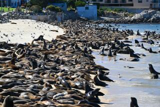
The beach at Water Canyon is three miles of white sand on the fringe of Bechers Bay. It offers the easiest hiking on the island, and itâs just a 10-minute walk from the airstrip. The beach has tide pools, dramatic sandstone formations and sand dunes.
See more of John McKinneyâs tips at www.thetrailmaster.com.
More to Read
Sign up for The Wild
Weâll help you find the best places to hike, bike and run, as well as the perfect silent spots for meditation and yoga.
You may occasionally receive promotional content from the Los Angeles Times.


