Ready for StormŌĆÖs Worst
A powerful winter storm is expected to drop as much as 4 inches of rain on parts of Orange County this morning, after drenching sections of Ventura and Santa Barbara counties on Monday.
Forecasters fear the rains could lead to mudslides in Orange County canyons and flash floods along creeks, rivers and low-lying sections of the coast. Winds gusting to 40 mph are possible in higher elevations, with sustained winds of 25 mph elsewhere.
By evening, the storm should pass through to the east, leading to a couple days of nice weather before another, less-intense, storm moves in on Friday.
And we canŌĆÖt even blame El Nino.
ŌĆ£ItŌĆÖs definitely stronger than a normal storm, but as far as El Nino is concerned, we canŌĆÖt say whether itŌĆÖs playing any part in intensifying it,ŌĆØ said Wes Etheredge, forecaster for WeatherData, which provides weather information to The Times.
Joe Dandrea, a forecaster for the National Weather Service, said the storm began in the north Pacific and moved southeast, the leading edge dropping a half-foot of rain over portions of Ventura and Santa Barbara counties Monday. It was expected to move over Los Angeles and Orange counties overnight.
Officials for MetroLink added cars to commuter trains for the Tuesday runs, anticipating additional passengers trying to avoid backed-up freeways. Emergency rail crews also stood by in southern Orange County to shore up tracks along the ocean in case of erosion from heavy ocean swells.
Orange County Fire Authority Capt. Scott Brown said storm preparations Monday included raising the height of a sand berm along the coast in Seal Beach, where homes flooded in December.
Crews drained 2 1/2-foot-deep pools of water that collected between the berm and oceanfront homes during FridayŌĆÖs heavy surf. City workers also replaced support beams on Seal Beach Pier, which took a beating in earlier storms. Farther south, Aliso Beach Pier was closed as a precaution. Hundreds of sandbags were distributed among county fire stations for the publicŌĆÖs use, and officials warned people to avoid creeks and storm channels.
ŌĆ£The key here is preparedness,ŌĆØ Brown said. ŌĆ£We have to be ready. And smart.ŌĆØ
The countyŌĆÖs storm center was relatively quiet Monday, with most staffers home to rest in anticipation of a long night. Forecasters for the county expected the rains to begin Monday night but only as a dribble, with the major deluge arriving in the early morning.
ŌĆ£WeŌĆÖre not expecting anything heavy to come down until 2 or 3 a.m.,ŌĆØ said Bill Reiter, county operations manager. ŌĆ£Then weŌĆÖre expecting it to last as long as until noon. We could get as much as 3 to 5 inches in Orange County, depending on where youŌĆÖre at.ŌĆØ
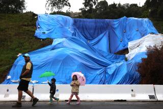
The greatest concern, Reiter said, are the canyon areas, especially near Baker Canyon, where the land is still barren from an October wildfire, making it vulnerable to mudslides. In December, heavy rains closed roads near the charred canyon for 12 hours as crews cleared mud and debris.
ŌĆ£We got beat up pretty bad out there in the last storm, so thatŌĆÖs a worry,ŌĆØ Reiter said.
Another at-risk spot may be the low-lying southwest communities, such as Huntington Beach and Westminster, where sustained downpours could overwhelm the latticework of flood-control channels. Crews recently finished $4 million in repairs to dirt banks and concrete linings that eroded in December, he said.
ŌĆ£We had oodles of trouble there before,ŌĆØ Reiter said, adding that Huntington Beach contended with major flooding in 1993 and 1995.
As the storm neared Monday, wind-driven swells continued battering western-facing beaches, not to mention ships at sea.
Dana Point lobsterman John Guth spent the day ŌĆ£rounding up straysŌĆØ--traps that drifted over the weekend under the pressure of huge ocean swells.
Guth said he found some of his wire traps two miles from where he had dropped them, and several were dented from being dragged across the rocky seabed. With another storm due today, Guth decided to gather about two dozen of his most vulnerable traps before they could be swept away.
ŌĆ£IŌĆÖve had enough,ŌĆØ Guth said, washing down his boat. ŌĆ£There are big swells out there about 15 feet and theyŌĆÖre getting bigger.ŌĆØ
Public work crews in Laguna Beach, which suffered heavy damage in the December floods, spent the last few days clearing storm drains and gathering sandbags, said Terry Brandt, director of Laguna Beach municipal services. But some residents and shop owners spurned sandbags--which washed away in December--in favor of wooden crates and boards.
Kelly Kellar, manager of the Laguna Beach Big Dog clothing store, spent two days hoisting merchandise racks atop crates and pallets to avoid damage from a repeat of the December storm, when rushing waters washed away their sandbags and crashed through the front door, ruining thousands of dollars in merchandise.
ŌĆ£WeŌĆÖre going to put these boards up and all the merchandise, weŌĆÖre going to put it up high,ŌĆØ Kellar said.
But Brian Freitag, bartender for the Ocean Brewery Co., stuck to tradition, and what has become a regular part of his job: sandbag deployment.
ŌĆ£We keep them up now all the time, and when thereŌĆÖs a storm we strip off the top layer and put it in the doorway,ŌĆØ Freitag said.
Not everyone was putting full faith into the storm predictions.
Bob Adams, owner of Balport Security, planned to sandbag the front of his shop even though heŌĆÖs skeptical about the threatened deluge. His store was flooded by 18 inches of water during the last big storm.
ŌĆ£I donŌĆÖt really believe itŌĆÖs going to happen,ŌĆØ he said.
But at Areo, a gift shop just a few doors away, most vases, candlestick holders and other breakables were already stowed away Monday, and homemade floodgates--wooden boards--spanned the doorway.
ŌĆ£We still have everything up on blocks since the last time, and our floodgates are up,ŌĆØ said employee Alix Primack. ŌĆ£Hopefully, we wonŌĆÖt have to worry.ŌĆØ
Times staff writers Geoff Boucher, Shelby Grad and Bonnie Hayes contributed to this report.
(BEGIN TEXT OF INFOBOX / INFOGRAPHIC)
Water Hazards
Rain-slick freeways can be dangerous, especially for motorists who seldom drive in wet weather. If your vehicle begins to skid, resist the impulse to jerk the steering wheel and slam on the brakes, which aggravates a skid.
To recover from a skid:
1. Release brakes to unlock wheels, take foot off accelerator, steer in direction of skid.
2. Lightly tap brakes while car straightens.
3. Continue to slow car until control is regained.
* Hydroplaning: In heavy rain or on oily segments of road, tires can briefly lose contact with he surface, a condition called ŌĆ£hydroplaning.ŌĆØ Lightly apply brakes until tires touch the road again.
* Distance: Maintain space on all sides to brake or maneuver; a car length for every 10 mph is recommended, but is not usually a freeway reality.
* Brakes: May become soaked in deep puddles, making stopping difficult. Dry them by simultaneously pressing gas and brake pedals. Do this only until brakes begin to work.
* Best advice: Leave early and drive slowly.
Source: Times reports
Avoid These Trouble Spots
Two stretches of Orange County road can be particularly troublesome because of flooding during periods of major rainfall: Pacific Coast Highway through Sunset Beach and near the Bolsa Chica wetlands, and Laguna Canyon Road from the lakes to El Toro Road. Here are suggested alternate routes should water make things impassable:
More to Read
Sign up for Essential California
The most important California stories and recommendations in your inbox every morning.
You may occasionally receive promotional content from the Los Angeles Times.


