The science behind Hurricane Sandy: a confluence of trouble
WASHINGTON — Hurricane Sandy seems straight out of a Hollywood apocalyptic blockbuster. But a confluence of environmental and topographical characteristics helps explain its vast size, slow progress, storm surge and multiple methods of wreaking havoc on the coast and deep inland, scientists say.
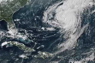
Sandy began as a big storm when it formed in the Caribbean, said Katie Garrett, a meteorologist with the National Weather Service. It grew as it moved north into the mid-Atlantic, fed by unseasonably warm waters.
Sandy stretches about 940 miles — greater than the distance from New York to Atlanta — said Jeff Masters, co-founder of WeatherUnderground.com and a former flight meteorologist with the National Oceanic and Atmospheric Administration’s hurricane hunters. Sandy is the largest such storm to make landfall on the Eastern Seaboard since 1988, when the government acquired the satellite technology and aircraft to start measuring the size of storms.
PHOTOS: Hurricane Sandy approaches
Sandy’s course, from southeast to northwest, is not typical, said Rick Knabb, director of the National Hurricane Center in Miami. Although its path is “not 100% unprecedented,” it is unusual for a storm of such size and strength to move inland so late in the year, Knabb said during a telephone news conference Monday.
Even when Atlantic storms come ashore, they usually head back out to sea. Some powerful storms in recent years did not make landfall at all, kept away by weather patterns. But Sandy was pushed into the mid-Atlantic states and New England because a high-pressure system near Greenland blocked its progress eastward.
That shift toward the northwest put Sandy on course to mesh with a cold front that began in California last week and marched across the country, creating what Knabb and others say is an unprecedented weather threat. The force of the eastward-moving front slowed Sandy, Garrett said, changing the hurricane into a nor’easter.
MAP: Hurricane Sandy barrels in
Even before coming ashore, Sandy had begun to lose traits typical of tropical storms, such as thunderstorms at its middle, Garrett said. Instead, Sandy’s merger with the cold front threatened to cause severe snow in places. In West Virginia, 3 to 4 feet were predicted in some areas, with less snow in southwestern Virginia and western North Carolina.
“It’s not just a tropical storm, but a windstorm, a snowstorm,” Garrett said.
Sandy also has produced dramatic storm surges. The swirling movement of its winds created a big bulge of water that typically moves to a storm’s center. There, the low pressure in the atmosphere acts like a straw and pulls the water levels even higher, Masters said. If a storm is farther out to sea, that bulge eventually sinks. But because Sandy moved to shallower waters near the coast, that bulge had nowhere to go but toward shore, he said.
PHOTOS: Massive U.S. storms -- Frankenstorm, Snowpocalypse and more
The slowness of the storm meant it could sit over the East Coast through several high tide cycles. Scientists were predicting 10- to 11-foot storm surges, including high tide conditions, in places like New York and New Jersey. Monday night’s full moon threatened to add another foot to the surge, Knabb said. Finally, many inlets and bays in the mid-Atlantic are funnel-shaped, which means water can surge in easily, but getting out is a challenge.
Knabb said he didn’t expect water levels to return to normal until Wednesday.
More to Read
Sign up for Essential California
The most important California stories and recommendations in your inbox every morning.
You may occasionally receive promotional content from the Los Angeles Times.


