Hurricane Isaac hovering over Gulf Coast; so far, levees holding
NEW ORLEANS -- With torrential rain and wind gusts of up to 100 mph, Hurricane Isaac pounded New Orleans and the Gulf Coast from Louisiana to Alabama on Wednesday morning, the seventh anniversary of catastrophic Hurricane Katrina.
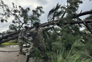
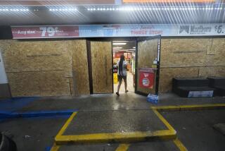
More than 494,000 customers were without power in Louisiana, 158,000 of them in Orleans Parish, as winds toppled trees and ripped down power lines. City officials warned that New Orleans faced hurricane conditions until Thursday as the storm slowed to a crawl and hovered over southern Louisiana and the Mississippi Gulf Coast.
In Plaquemines Parish south of New Orleans, where Isaac crashed ashore late Tuesday, authorities reported water lapping over an 18-mile levee in a thinly populated stretch of marsh and bayou near the mouth of the Mississippi River.
ŌĆ£The water came up so quickly and overtopped the levees from Breakaway to White Ditch on the east back of the north end of the parish,ŌĆÖŌĆÖ Harold ŌĆ£BillyŌĆØ Nungesser, president of Plaquemines Parish, told ABCŌĆÖs ŌĆ£Good Morning America.ŌĆØ ŌĆ£ItŌĆÖs an area that we called for a mandatory evacuation.ŌĆÖŌĆÖ
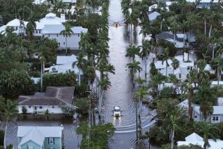
In New Orleans, which was banking on a shored-up levee and pump station system to protect it from surging waters, at least 29 streets were flooded. Sections of U.S. Highway 90, which runs along the Gulf coast in southern Mississippi, were also reported to have been closed by floodwaters.
As the night wore on, the broad, slow-moving storm settled like a massive flying saucer over the city. By 4 a.m. Wednesday, the suburb of Kenner, La., where the international airport is located, was in the dark. Lightning illuminated the sky through a thick blanket of clouds, casting the city in a ghostly glow. The highways were deserted, except for a handful of emergency vehicles with flashing lights.
New Orleans Mayor Mitch Landrieu, noting that several ŌĆ£knuckleheadsŌĆÖŌĆÖ had approached roiling waters near the edge of the Mississippi River, pleaded with residents to stay indoors and to resist the urge to venture out to check on the hurricaneŌĆÖs effects.
ŌĆ£Isaac is testing everyoneŌĆÖs patience with its slow movement through south Louisiana,ŌĆÖŌĆÖ Bill Mohl, Entergy Louisiana president and chief executive, said in a statement Wednesday morning. ŌĆ£We are ready to mount a counterattack to IsaacŌĆÖs onslaught as soon as the weather conditions allow us to do so.ŌĆÖŌĆÖ
Emergency officials said power crews cannot operate until winds subside to 30 mph. Maximum sustained winds remained at 80 mph Wednesday morning, the National Hurricane Center reported, with hurricane-force winds expected for much of the day. The center also warned of a dangerous storm surge throughout the day and into the night.
The mayor of Mandeville, a city of about 11,500 on the shores of Lake Pontchartrain, was out surveying the storm Wednesday morning and said water had flooded a few blocks north of the lake -- not enough to damage homes. Such flooding was expected; officials from the city and surrounding St. Tammany Parish had earlier called for a voluntary evacuation of the low-lying area.
ŌĆ£The water from the lake is topping the wall, the seawall is five feet above sea level. The rain is as hard now as it has been, the wind has picked up. WeŌĆÖre catching now the worst part of the storm,ŌĆÖŌĆÖ Mayor Donald Villere told the Los Angeles Times by phone as he stood surveying Lakeshore Drive.
The storm will slowly crawl over Louisiana Wednesday and into the night and over Arkansas after that, the center reported. At 6 a.m. CDT, Isaac had slowed to just 6 mph, with its center about 50 miles south-southwest of New Orleans.
The U.S. Army Corps of Engineers, which spearheaded an $11-billion effort to repair and upgrade New OrleansŌĆÖ system of levees, flood walls and pump stations, said the system was holding up against floodwaters in the city.
ŌĆ£The Hurricane and Storm Damage Risk Reduction System is performing as designed,ŌĆÖŌĆÖ Kristen Kendrick, a spokeswoman for the Corps, said in an email message. ŌĆ£We are confident in the system.ŌĆÖŌĆÖ
But another hurricane-related threat loomed: The National Oceanic and Atmospheric Administration warned of isolated tornadoes along the central Gulf Coast and parts of the lower Mississippi Valley throughout the day Wednesday.
Susman reported from New Orleans; Hennessy-Fiske from Los Angeles.
ALSO:
2 years for 16th DUI? Maximum allowed, prosecutors say
Bigfoot hoax ends badly: Montana jokester hit, killed by car
New fuel economy standards would boost average car to 54.5 mpg
Join Molly on Google+ and Twitter @mollyhf. Email: [email protected]
More to Read
Sign up for Essential California
The most important California stories and recommendations in your inbox every morning.
You may occasionally receive promotional content from the Los Angeles Times.


