JulyŌĆÖs record-breaking rainfall may not be over yet

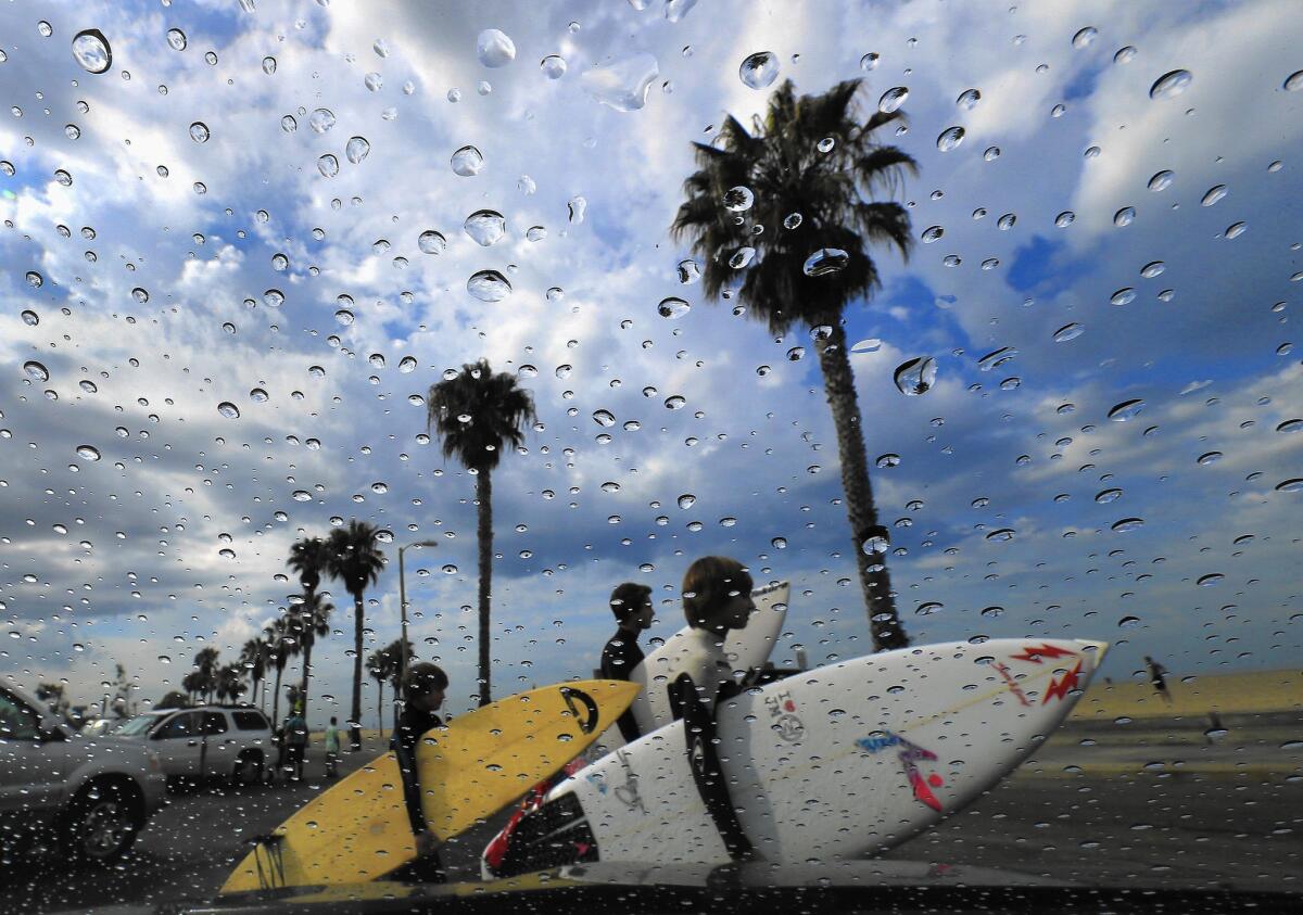
Rain gathers on a windshield and storm clouds roll in as surfers head out to the beach July 18. The surfers ended up turning around and heading home after they were advised by Los Angeles County Fire Department lifeguards that all Los Angeles County beaches were closed.
July ŌĆö already one of the wettest in CaliforniaŌĆÖs history ŌĆö is expected to go out with one more drenching.
Forecasters say a monsoonal flow could hit Southern California on Wednesday, bringing more rain, thunder, lightning and muggy conditions into the weekend.
The weather, which officials believe is tied to the El Ni├▒o system building in the Pacific, has been marked by contradictions.
The rain has helped contain some brush fires and brought a small respite from four years of drought.
At the same time, the storms caused scattered road damage and prompted lifeguards to clear out beaches during the peak summer season as a safety precaution. Last year in Venice, a surfer was struck by lightning and died.
ŌĆ£ItŌĆÖs a bit of a conundrum. You get a lot of rain in a short period of time ŌĆ” and within a week, weŌĆÖre right back to where we were,ŌĆØ said Gary Wuchner, a fire specialist at Yosemite National Park.
Perhaps nowhere is the dichotomy playing out more than at Yosemite, where last week a storm dropped nearly two inches of rain, reducing the parkŌĆÖs July fire risk to a level not seen in years. At the same time, lightning from the storms sparked about half a dozen wildfires.
ŌĆ£You get this much rain in this short period of time, Yosemite Falls more or less woke up and the rivers rose,ŌĆØ Wuchner said. ŌĆ£YouŌĆÖre up here for so many years, you see whatŌĆÖs going on. It doesnŌĆÖt take a scientist to see, ŌĆśWow, we got some water.ŌĆÖ It takes the edge off.ŌĆØ
Last weekŌĆÖs storms were so intense that they caused a mud and rock slide on Highway 140 leading to the parkŌĆÖs western edge.
The debris, which fell from a hillside that burned during the El Portal fire last year, was so extensive that the road ŌĆö one of only three main routes to the park from the west ŌĆö remained closed for two days until Thursday evening.
Crews are monitoring about a dozen small lightning-caused fires in the parkŌĆÖs higher elevations. Wuchner said the rain proved to be a remarkable ally, extinguishing nearly half a dozen fires.
Earlier this month, the National Interagency Fire Center in Idaho amended its fire season outlook for Northern California after a series of early July storms.
ŌĆ£These are unusual fuel moisture trends for the time of year, but the result is reduced potential for large fires in the north and east sectionsŌĆØ of Northern California, the agency said.
Some fire officials are less optimistic. They say the summer heat immediately kills whatever green shoots sprout up after rain, creating another layer of fuel to burn.
Climatologists believe the rain is the result of El Ni├▒o, a weather phenomenon characterized by the warming of Pacific Ocean waters west of Peru that causes changes in the atmosphere and can dramatically alter weather worldwide.
Last weekŌĆÖs rains came from remnants of Hurricane Dolores. Warmer ocean temperatures allowed the former hurricane to make landfall in California with more moisture and strength than if the ocean was as cool as it normally is.
The source of this weekŌĆÖs expected storms is a monsoonal system centered over Arizona and Texas via Mexico, forecasters said.
The unusually warm waters in the Pacific are behaving like a siren for hurricanes off Mexico like Dolores, which drew humid air and punishing thunderstorms north to California, where theyŌĆÖve slammed head-on with the stateŌĆÖs drought conditions, forecasters say.
ŌĆ£This is certainly the most active [July] IŌĆÖve seen since IŌĆÖve been here,ŌĆØ said Tom Dang, a meteorologist in the National Weather ServiceŌĆÖs Sacramento office for the last seven years.
ThereŌĆÖs a favorable chance that this winter will be wetter than average in much of California ŌĆö from San Diego to San Francisco. The greatest chance for wet conditions is in Southern California, Mike Halpert of the National Oceanic and Atmospheric AdministrationŌĆÖs Climate Prediction Center said recently.
But, for now, thereŌĆÖs only an equal chance of a wetter-than-average rainy season north of San Francisco, where much of the stateŌĆÖs water supply is collected and stored in giant reservoirs. California needs both rain and snow up there. Snow slowly melting from the mountains is essential to recharging the reservoirs later in the spring.
A typical El Ni├▒o generally dumps heavy rain only on Southern California. But the most powerful El Ni├▒os on record, 1982-83 and 1997-98, were strong enough to send dramatic storms over Northern California as well.
This yearŌĆÖs El Ni├▒o could be as strong or stronger as the 1997-98 El Ni├▒o. On July 22, a key benchmark location in the Pacific Ocean was 2.88 degrees above average. ThatŌĆÖs similar to the temperature reading July 23, 1997, which was 3.06 degrees above average.
Typically, winds along the Pacific Ocean at the equator move east to west. ThatŌĆÖs why ocean water on Indonesian beaches is so warm. As winds move warm water west, the eastern Pacific OceanŌĆÖs surface along the equator is chilled as deep ocean water wells up.
In big El Ni├▒o years, the so-called trade winds weaken, allowing the eastern Pacific Ocean to warm up more ŌĆö making El Ni├▒o even stronger.
El Ni├▒o can produce heavy precipitation in California by bringing something called the subtropical jet stream over the state.
This current of air usually runs over the jungles of southern Mexico and Nicaragua, a reason Central America has rain forests, said Bill Patzert, climatologist with NASAŌĆÖs Jet Propulsion Laboratory in La Ca├▒ada Flintridge.
The subtropical jet stream has already shifted north and is somewhat responsible for the devastating storms that pelted Texas and Oklahoma this spring and pushed those states out of drought, Patzert said.
ŌĆ£If it continues to warm up in the eastern Pacific, as we get into fall and winter, the subtropical jet stream could move across the southern tier of the United States,ŌĆØ Patzert said.
Twitter: @josephserna
Twitter: @ronlin
ALSO:
Struggle to save endangered Santa Ana sucker may reach U.S. Supreme Court
Hey, California, you can still have a lawn! Here are five water-wise alternatives
ItŌĆÖs critical El Ni├▒o hits Northern California. Why experts are growing optimistic.
More to Read
Sign up for Essential California
The most important California stories and recommendations in your inbox every morning.
You may occasionally receive promotional content from the Los Angeles Times.


