Unfinished Road Makes Great Footpath
With its towering rock walls and dramatic V-shaped gorge, the East Fork of the San Gabriel River is monumental in scale, boasting some of the most rugged relief in all of Southern California. The hiker gazing down at the river or up the dizzying canyon walls to the rim might conclude this is a perfect environment for reclusive bighorn sheep. In fact, Sheep Mountain Wilderness, which surrounds the East Fork, was designated in 1984 to provide a protected habitat for the numerous Nelson bighorn sheep that roam the precipitous slopes above the river.
One would logically conclude that such terrain would discourage engineers from even thinking about building a highway up the East Fork to connect with Angeles Crest Highway. But two generations of road builders have tried to bulldoze, blast and bridge a road up the East Fork.
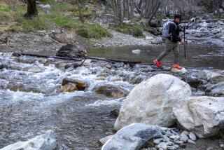
The first attempt began in 1929 when road crews constructed a highway in the lower reaches of the great canyon. The âstorm of the centuryâ (March 1, 1938) hit the mountains, and the San Gabriel River ripped the roadway to pieces. Left behind was the âBridge to Nowhere,â a reminder of natureâs power now crossed only by hikers.
In 1954, engineers attacked the East Fork again. This time the Los Angeles County road department, using inmate labor, began constructing the highway high on the west wall of the canyon to avoid the possibility of another flood. Despite 15 years of hard work by the prisoners of Detention Camp 14, only 4.5 miles of road were completed.
In 1969, county budget cuts and protests by conservationists led officials to halt construction. When the area was granted wilderness status in 1984, there was little possibility the highway project would ever be revived.
âConvict Road,â as it was known back then, stands today as a monument to bad planning. Visitors may drive the first third of the road and hike the balance of the âRoad to Nowhere.â Highlights of the hike include two tunnels of early 1960s vintage and grand vistas of the East Fork of the San Gabriel River.
Directions to trail head: From the Foothill Freeway (210) in Azusa, take the Azusa Avenue-California Highway 39 exit and head north about 11.5 miles to East Fork Road. Turn right (east) and drive 3.3 miles to a junction with signed Shoemaker Canyon Road. Bear left and follow it two miles to the end of the paved road, a vehicle gate and a parking area. On the return trip, hungry and thirsty hikers can stop for refreshments at Follows Camp, just off East Fork Road, a short distance west of its junction with Shoemaker Canyon Road. The camp boasts a colorful place known as the Fort, a combination restaurant, saloon and general store.
The hike: Step around the vehicle gate and begin a moderate ascent on the graded dirt road. Shade en route is scarce--limited to the towering walls left by the road cuts. About 1.75 miles of hiking brings you to the first tunnel, an ambitious enterprise more than 1,000 feet long. The road narrows a bit, dips and climbs to a second tunnel, about 700 feet long. Beyond the second tunnel, a brush-overgrown footpath continues 75 yards to the head of a steep ravine.
Shoemaker Canyon was named for grizzled gold miner Alonzo Shoemaker, who worked this small, steep tributary of the East Fork during the 1870s and 1880s. To take in the sights and sounds of the mighty East Fork of the San Gabriel River, backtrack 75 yards or so on a brushy path leading south outside the tunnel. Admire the view of the grand chasm as well as mighty Iron Mountain (8,007 feet) in the midst of the Sheep Mountain Wilderness, then retrace your steps through the tunnels back to the trail head.
For more of John McKinneyâs hiking tips and trails, visit Internet https://www.thetrailmaster.com.
(BEGIN TEXT OF INFOBOX / INFOGRAPHIC)
Shoemaker Canyon Trail
WHERE: Angeles National Forest, near Sheep Mountain Wilderness.
DISTANCE: From Shoemaker Canyon Road to Second Tunnel is 5.5 miles round trip with 800-foot elevation gain.
TERRAIN: Rugged, chaparral-cloaked slopes.
HIGHLIGHTS: Walk âBridge to Nowhere,â enjoy dramatic vistas of East Fork, San Gabriel River.
DEGREE OF DIFFICULTY: Easy to moderate.
FOR MORE INFORMATION: Angeles National Forest, 701 N. Santa Anita Ave., Arcadia, CA 91006; tel. (626) 574-1613.
More to Read
Sign up for The Wild
Weâll help you find the best places to hike, bike and run, as well as the perfect silent spots for meditation and yoga.
You may occasionally receive promotional content from the Los Angeles Times.


